

Latest Weather Blog
Friday AM Forecast: Slightly lower humidity leading into the weekend
The best time to work outside will be in the morning hours before 10 am. Another Heat Advisory is out for today, but the humidity will be slightly better.
*HEAT ADVISORY* for the shaded area. Keep an eye on kids, pets, the elderly and check the backseat! #lawx #mswx pic.twitter.com/cLvr9qK0L4
— WBRZ Weather (@WBRZweather) September 3, 2021
THE FORECAST
Today & Tonight: The National Weather Service has issued another precautionary heat advisory from 10am though 6pm today. This afternoon the heat index will max out in the 90s with some areas in the triple digits. Take it slow while working outside and drink plenty of water. The best time to work outside will be between sunup and 10am. Lower humidity also means there is not enough moisture for afternoon rain. Showers and storms will hold off today. Overnight conditions will be less muggy with temperatures near 70 degrees.
Up Next: Temperatures will be in the low 90s with the heat index scratching 100. A heat advisory may be reissued over the weekend to encourage all to exercise caution in the heat even though we have had hotter days this year. These same dry conditions will continue through the weekend. Overnight temperatures will dip into the 60s for some areas north of Baton Rouge. If you don’t reach the 60s the low 70s will still feel better with lower humidity. Click here to see the 7-day forecast. Think about your neighbors and avoid burning debris at night in order to not smoke out your neighbors while windows are open. Afternoon showers and summertime humidity will return early next week.
In the Tropics:
Trending News
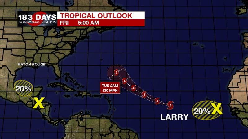
Hurricane Larry is expected to become a major hurricane out in the Atlantic and follow the same path as Kate north through the central Atlantic. It is going to be a fish storm, and not a threat to anyone.
A surface trough over the Gulf of Honduras and portions of Central America is producing disorganized shower and thunderstorm activity. This system is expected to move west-northwestward across Central America and the Yucatan Peninsula, bringing heavy rains to that area during the next couple of days. The disturbance could then move over the southwestern Gulf of Mexico late this weekend, but unfavorable upper-level winds are likely to limit significant development while the system moves northwestward or northward over the western Gulf of Mexico early next week.
Showers and thunderstorms have decreased tonight in association with an area of disturbed weather located about 100 miles south of the southernmost Cabo Verde Islands. In addition, recent satellite derived wind data indicate that the system does not have a closed circulation. This disturbance is expected to move westward into an environment less conducive for development during the next couple of days, and the chances of formation appear to be decreasing. This system could bring showers and gusty winds to portions of the southernmost Cabo Verde Islands during the next several hours.
The WBRZ Weather Team is watching the tropics around the clock and will bring you updates as they come. Click here to visit the Hurricane Center.
Need weather conditions HOUR BY HOUR? Get hour by hour weather and right now weather conditions for your location on the WBRZ WX App on your Apple or Android device. Follow WBRZ Weather on Facebook and Twitter for even more weather updates and unique weather insight from the whole team!
More News
