

Latest Weather Blog
Friday AM Forecast: Not a total washout but showers in the forecast
A fabulous Friday forecast... with some interrupting showers.
THE FORECAST
Today & Tonight: Southerly winds bringing in plenty of moisture this morning. Coastal showers are bubbling up and moving inland. Thick cloud cover early in the day will cap our temperatures to the high-80s across the Capital Area. Most people will see a shower again this afternoon. Some of these showers and storms have the potential to produce heavy downpours, gusty winds, or frequent lightning. The marginal risk for excessive rainfall is still in effect for our area as the storms make their way through the area. Localized some street and poor drainage flooding is possible. These showers will not ruin any Friday night plans, maybe just have an indoor plan just in case. Overnight cloud cover will stay put and we will see temperatures fall into the low-70s.
Up Next: Saturday the pattern continues. The abundance of moisture will help fuel some showers across the area. These showers will be slow moving, and have the ability to drop 1-3” of rain per hour. This could potentially cause some street and poor drainage flooding issues. Heavy cloud cover will hold daytime high temperatures in the high 80s across the area. Once the showers begin to fizzle out across the area we will be waking up to temperatures in the low-70s with clouds. Showers are expected as we head into the rest of the weekend. No days will be total washouts. Seasonable temperatures and afternoon showers will stick around into the 4th of July weekend. Click here to see the 7-day forecast.
Hour-by-hour weather tracking is available for your location on the WBRZ WX App on your Apple or Android device. Follow WBRZ Weather on Facebook and Twitter for even more weather updates and unique weather insight from the whole team!
Trending News
In the Tropics:
Potential Tropical Cyclone 2 is bringing the threat of heavy rain and tropical storm force winds to countries in the Caribbean. This storm is not a threat to the local area. CLICK HERE to see the latest forecast cone for PTC 2.
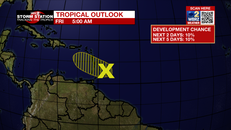
Western Tropical Atlantic:
A tropical wave located a few hundred miles east of the Windward
Islands is producing disorganized showers and thunderstorms. Any
development of this system should be slow to occur while the wave
moves west-northwestward during the next day or two. The wave is
forecast to move over the Windward Islands today and then over the
eastern Caribbean Sea by the weekend, where further development is
unlikely due to unfavorable environmental conditions.
* Formation chance through 48 hours...low...10 percent.
* Formation chance through 5 days...low...10 percent.
More News
