

Latest Weather Blog
Freeze bulletins issued for entire WBRZ Weather forecast area
Bitter winds will make for a cold Tuesday. Freezing temperatures and record lows are anticipated on Wednesday morning.
A HARD FREEZE WARNING has been issued for Pointe Coupee, West Feliciana, East Feliciana, St. Helena, Iberville, West Baton Rouge, East Baton Rouge, Ascension, Livingston and Tangipahoa Parishes as well as Wilkinson, Amite and Pike counties from midnight to 8am Wednesday. A FREEZE WARNING has been issued for Assumption and St. James Parishes.
Bulletin: On Tuesday night and Wednesday morning, temperatures could drop as low as 25 degrees for locations under a HARD FREEZE WARNING and below 32 degrees for locations under a FREEZE WARNING. Freezing temperatures could kill crops and sensitive plants. Where a hard freeze is expected, exposed, outdoor plumbing could be damaged. Take the necessary precautions to protect vegetation and cover or wrap exposed pipes. In any cold event, be sure that people and pets have access to warmth. Remember to use space heaters responsibility and not to burn open fires inside.
THE FORECAST:
Today and Tonight: Most, if not all, precipitation will wrap up around daybreak Tuesday. While clouds will slowly break into the afternoon hours, any sunshine will be overcome by stiff northerly winds and air temperatures will not warm far beyond the upper 30s and low 40s.
Trending News
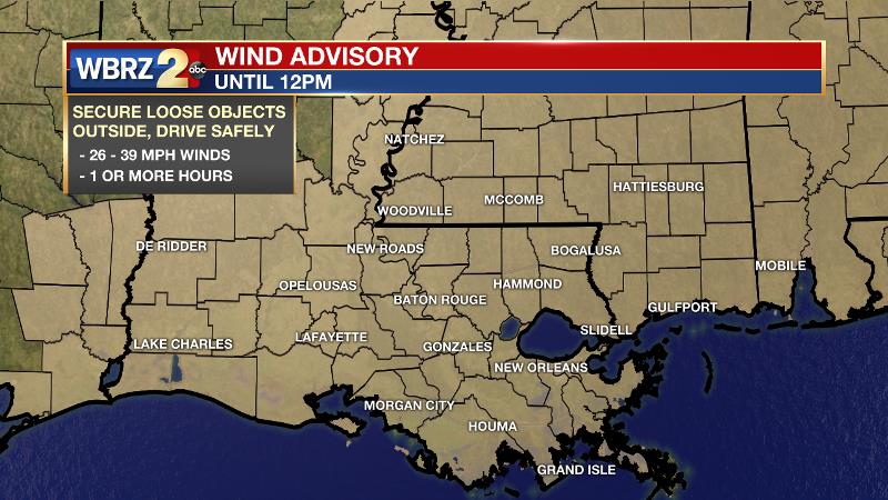
A WIND ADVISORY has been issued for the entire area through noon. Make sure loose outdoor objects are secured and be careful driving, especially in high profile vehicles. The 10-20mph breezes will cause wind chills, or feels-like temperatures to stay in the upper 20s and low 30s all day.
IMPORTANT NOTE: Even though actual air temperatures will bottom out in the 20s on Wednesday morning, much of Tuesday will feel just as cold due to winds. #WindChill #LaWX #MsWX pic.twitter.com/DyTYFQIsSI
— Josh Eachus (@DrJoshWX) November 11, 2019
With winds decreasing overnight and clear skies, the area is poised to meet freezing for the first time this season. Lows will dip into the mid 20s along and north of I-12 and upper 20s and low 30s along and south of I-10. Take precautions for sensitive vegetation and make sure livestock or pets have access to warmth. Especially north of I-12, it might be a good idea to take the recommended pipe precautions out of an abundance of safety.
A couple of @BTRairport record lows are in danger over the next 48 hours. While a record of 30 is not likely Tuesday morning, the Nov. 12 record could still fall after sunset when temps. plummet. Wednesday morning is virtually a lock for a new record low. #BatonRouge pic.twitter.com/Tfxq9r6rnB
— Josh Eachus (@DrJoshWX) November 11, 2019
Up Next: Sunshine will guide high temperatures back into the low 50s on Wednesday and the mid 50s on Thursday though some rain showers may return to the area. A cool, albeit relatively warmer, and dry weekend is ahead.
The Tropics: For the North Atlantic, Caribbean Sea and the Gulf of Mexico, tropical cyclone formation is not expected during the next 5 days. This is the final official month of hurricane season.
THE EXPLANATION:
A deep trough will envelop the eastern half of the country on Tuesday and Wednesday. This trough caused a potent cold front to move through the local area. The greatest impact from this cold blast will be the wind chill and temperatures. Despite some clearing on Tuesday, strong north winds of 10-20mph will continue to advance cold air into the region. Not only will this overcome any sun to prevent warming, but the blustery conditions will cause air temperatures in the upper 30s and low 40s to feel like they are in the upper 20s and low 30s. This wind chill factor will continue into Wednesday morning, albeit not as significant as winds slacken. However, Wednesday morning is when air temperatures will be tumbling below freezing for the first time this season. Model guidance suggests that a hard freeze (<25°) is even possible for locations along and north of I-12. The National Weather Service has issued coincident HARD FREEZE and FREEZE WARNINGS to detail these possibilities (see above). A slow warming trend will begin on Wednesday afternoon with some showers back in the picture by Thursday. Next weekend, high temperatures will return to the 60s.
--Josh
The WBRZ Weather Team is here for you, on every platform. Your weather updates can be found on News 2, wbrz.com, and the WBRZ WX App. on Apple and Android devices. Follow WBRZ Weather on Facebook and Twitter for even more weather updates while you are on the go.
More News
