

Latest Weather Blog
Cool nights ahead, next storm system arrives Friday
With a strong late April cold front moving south, freeze warnings have been posted for areas north of Louisiana. Thermometers will be about 10 degrees below average from tonight through Friday afternoon.
Next 24 Hours: A weak cold front will slide through the region tonight, but with little noticeable weather. It is possible some clouds are stirred up, as winds shift to the northwest at 10-15mph. Much cooler air will dive into the Gulf South with low temperatures slated for the upper 40s and low 50s. Wednesday will be a beautiful, if not cool, day. Despite ample sunshine, high temperatures are unlikely to leave the upper 60s. Winds will remain out of the north at about 10mph.
Up Next: On Thursday morning, thermometers will hit their lowest marks of the week with many starting in the low to mid 40s. Skies will stay mainly clear. A stronger storm system will cut across the southern third of the country Friday into Saturday. This one is expected to return showers and thunderstorms to the local area for about a 24-hour period. Fortunately, that will not allow for a long duration soak like the one we just experienced. However, the associated surface low will take a track close enough to the area to warrant the early 2/5 “slight risk” of severe weather posted by the Storm Prediction Center. Most likely, any stronger thunderstorms would occur late Friday night and early Saturday. The second half of the weekend is expected to be drier. CLICK HERE for your full 7-Day Forecast.
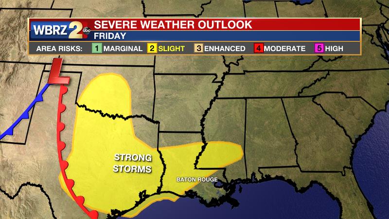
The Explanation: Cooler air will settle over the region on Wednesday with high temperatures 10-15 degrees below average in the upper 60s. A dry atmosphere will result in clear skies. By Thursday morning, persistent cold air advection and clear skies with lighter winds could allow some lows in the low 40s well north of I-12! Thursday will remain pleasant with the possibility of some cirrus clouds emerging by late in the day. By Friday, an area of high pressure positioned northeast of the local area will return southerly winds and moisture to the atmosphere. The advance of this air mass will occur along a warm front Friday afternoon with associated overrunning precipitation breaking out ahead of that. The associated cold front will run through by Saturday afternoon. Through this time, showers and garden variety thunderstorms are all that is expected. Moving into Friday night and Saturday morning, the Storm Prediction Center highlighting the entire local area with a 2/5 “slight risk” for severe weather. The biggest questions, which will answer what type of severe weather could occur, will be whether the instability ahead of an approaching cold front can become rooted at the surface. These details will become clearer over the next few days. The cold front will move into the Gulf of Mexico on Saturday night with drier air returning for the duration of the weekend.
Trending News
--Josh
The WBRZ Weather Team is here for you, on every platform. Your weather updates can be found on News 2, wbrz.com, and the WBRZ WX App on your Apple or Android device. Follow WBRZ Weather on Facebook and Twitter for even more weather updates while you are on the go.
More News
