

Latest Weather Blog
Tuesday morning video forecast
Related Story
We will get some sunshine this afternoon and a cold front is coming in tomorrow.
THE FORECAST
Today & Tonight: A few light showers will be in and out this morning. Skies will be cloudy this morning with some sun peeking through this afternoon. High temperatures will be warm, in the upper 70s. Tonight will be muggy with lows in the mid-60s.
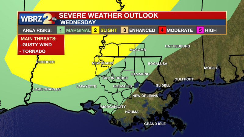
Up Next: The next front will reach the area on Wednesday evening. Ahead of the front, it will be muggy and warm with widespread showers moving in late Wednesday into early Thursday morning. Showers will make their way from northwest to southeast from about 10pm on Wednesday until 3 am on Thursday morning. You may hear a few rumbles of thunder overnight. There is a level 2/5 slight risk for severe storms for Point Coupee Parish, West Feliciana Parish, Amite County and Wilkinson County. All other areas have a level 1/5 marginal risk. The main concern with these storms will be isolated strong wind gusts. We can’t rule out large hail or a spin up tornado. Watch the full FUTURECAST track here.
The rest of Thursday is looking dry and cool. High temperatures on Thursday will be in the upper 60s and overnight lows will drop into the 40s. The next rainmaker is coming in on Saturday. Light on and off showers are expected through the day on Saturday and into Sunday too. Most areas will see rain, but rainfall totals will be less than 2 inches. That rain is expected to clear by the end of the day Sunday and Monday will start out dry. Click here to see the 7-day forecast.
Hour-by-hour weather tracking is available for your location on the WBRZ WX App on your Apple or Android device. Follow WBRZ Weather on Facebook and Twitter for even more weather updates and unique weather insight from the whole team!
News
