

Latest Weather Blog
Tuesday Morning Forecast
Related Story
After a break from the humidity yesterday, the muggy meter is creeping back up.
THE FORECAST
Today & Tonight: Starting off this Tuesday morning with mostly clear skies and temperatures in the low-70s. There is some patchy fog on the roads this morning, mainly for areas south of the interstates. The fog will break up as the sunrises. Into the afternoon, temperatures will climb back into the mid-90s. Feels like temperatures today will be from 99-101° during peak daytime hours. A little bit more moisture is added back into the forecast today and we will continue to see this trend for the rest of the workweek. A few spotty showers will be around this afternoon, but most people will stay completely dry.
Up Next: Temperatures to start your Wednesday will be in the low-70s, and daytime highs will break the mid-90s again. A few coastal showers will be possible, but most people will stay completely dry. Each day dew points will continue climbing, and that’s when we have to start keeping a close eye on feels like temperatures. Over the next few days, temperatures will continue to climb into the upper-90s and your feels like temperatures could be 10-15° warmer than the actual air temperature. For the rest of the workweek we are watching the upper-level pattern. Currently we are just downstream of a ridge. This is going to make it hard for showers to form and keep our forecast hot. Showers will be hard to find and feels like temperatures will start to creep back up near heat advisory status later in the week. Click here to see the 7-day forecast.
The Storm Station has you covered with hour-by-hour weather tracking is available for your location on the WBRZ WX App on your Apple or Android device. Follow WBRZ Weather on Facebook and Twitter for even more weather updates and unique weather insight from the whole team!
In the Tropics:
Tropical Storm Don has finally dissipated, and there are currently no active storms in the Atlantic basin.
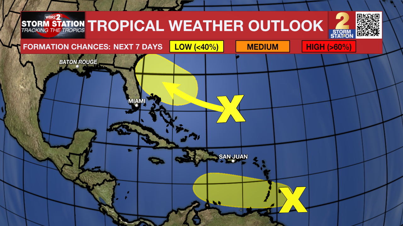
The Storm Station is watching two areas with overall low chance of development.
Near the Windward Islands (AL95):
A tropical wave located just east of the Windward Islands is
producing a large area of disorganized showers and thunderstorms
while moving quickly westward. Development, if any, of this system
should be slow to occur during the next day or two before it moves
into a region of unfavorable upper-level winds. Even though
development is unlikely, locally heavy rains and strong gusty winds
are expected across portions of the Lesser Antilles during the next
day or so.
* Formation chance through 48 hours...low...10 percent.
* Formation chance through 7 days...low...10 percent.
Southwestern Atlantic:
A weak trough of low pressure is located a few hundred miles
south-southwest of Bermuda. Some gradual development of this system
is possible while it moves west-northwestward towards the
southeastern U.S. coast later this week and into the weekend.
* Formation chance through 48 hours...low...near 0 percent.
* Formation chance through 7 days...low...20 percent.
News
