

Latest Weather Blog
Monday evening video forecast
Related Story
Temperatures will gradually warm in the days ahead. While warmth and humidity will not return to levels felt last week, it will be enough to rile up some showers and thunderstorms.
Next 24 Hours: One more comfortable night is on tap and mostly clear skies and light, east winds allow thermometers into the low to mid 50s. The weather pattern will slowly change on Tuesday. Winds will take on a southeasterly direction and let some Gulf of Mexico moisture creep back into the area. Some sun will push readings back toward the 80s. However, the added moisture may lead to a few more clouds than previous days.
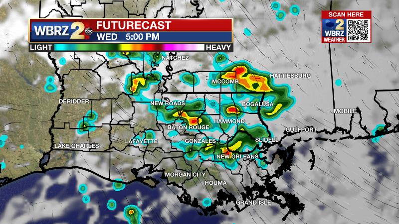
Up Next: Wednesday will begin quite a bit warmer than previous days with temperatures in the mid 60s. Thanks to much increased humidity and an approaching storm system, scattered showers and thunderstorms are expected for the afternoon hours. Though there are not currently any significant threats to the area, one or two strong storms are possible. The chance of showers will continue through Thursday until a weak cold front slides through the area. On the other side of that front, Friday into the weekend, humidity will again depart but temperatures will stay near their seasonal averages of highs near 80 and lows near 57. CLICK HERE for your full 7-Day Forecast.
The Tropics: For the North Atlantic, Caribbean Sea and Gulf of Mexico, tropical development is not expected over the next five days. For the latest tropical forecasts, advisories and information, visit the WBRZ Hurricane Center as we navigate all 183 Days of Hurricane Season.
The Explanation: A surface high pressure system will find its way toward the Eastern Seaboard on Tuesday allowing winds to slowly shift to the southeast over the local area. Moisture, indicated by dew point temperatures, will steadily climb and could be to the humid upper 60s by Tuesday night. A weak upper level trough of low pressure will cut across the northern half of the country and be centered north of the central Gulf Coast on Wednesday. This system will draw deeper moisture into the atmosphere and as surface temperatures rise, daytime warming will result in the development of showers and thunderstorms. The threat for severe weather is low but not zero, so we will continue to monitor this time period. A weak disturbance will pass through the upper levels on Thursday and this will help to trigger a bit more activity with the aid of afternoon warmth. Finally, Thursday night, a weak cold front associated with the upper level trough will swing through the area perhaps setting off a final round of showers and thunderstorms. The whole complex will move east of the area on Friday decreasing rain chances from west to east. In the wake of this front, drying, sinking air will result in clearing skies. A main difference with this front—there is no significant cold air trailing it, so while humidity will be low, temperatures will stay above average for the time of year.
--Josh
The WBRZ Weather Team is here for you, on every platform. Your weather updates can be found on News 2, wbrz.com, and the WBRZ WX App on your Apple or Android device. Follow WBRZ Weather on Facebook and Twitter for even more weather updates while you are on the go.
News
