

Latest Weather Blog
Friday 6 am weather update
Related Story
Storms this afternoon are coming in with a severe risk. Stay connected to the Storm Station.
THE FORECAST
The National Weather Service has issued a Severe Thunderstorm Watch for the entire WBRZ viewing area until 9 p.m.
A SEVERE THUNDERSTORM WATCH means conditions are favorable for thunderstorms to become severe in the form of damaging winds, large hail, heavy rain, or a possible tornado. If a Severe Thunderstorm Warning is issued, seek shelter in the same way you would for a tornado. Move to a low-level, interior room of a sturdy building (stay away from windows). Take pets (on a leash) with you, have on hard-soled shoes, monitor storm coverage on a wireless device. CLICK HERE for more safety tips.
*SEVERE THUNDERSTORM WATCH* for the shaded area. We're tracking storms and will bring you warnings if issued. #lawx #mswx pic.twitter.com/CTGiPV1k65
— WBRZ Weather (@WBRZweather) June 10, 2022
Severe thunderstorms will continue moving southeast across the watch area through early evening with a risk for damaging wind gusts and perhaps a tornado or two.
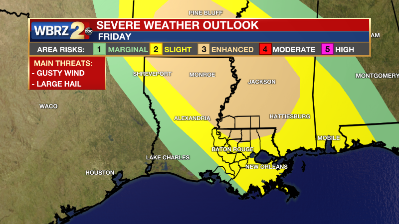
Today & Tonight: Temperatures will quickly climb into the 90s by early afternoon, then a cluster of storms will approach the area. There is a level 2/5 SLIGHT risk for storms to become severe in the Baton Rouge area. The risk is higher for counties and parishes north of EBR at a level 3/5 ENHANCED risk. The main threats are winds gusting 60mph or higher and large hail. We can’t rule out a spin up tornado or two. A Severe Thunderstorm Watch will likely be extended into the Baton Rouge area as storms get closer. Storms will be coming in between 3 p.m. and 7 p.m., moving generally north to south. Have a way to receive warnings. Be sure to avoid driving during a severe thunderstorm or flash flood warning. Straight-line winds can be just as damaging as a tornado. Take severe thunderstorm warnings seriously.
Reminder: With the threat for impactful weather— strong storms—please have access to alerts through Friday. You can download or activate the WBRZ WX App on your Apple or Android device or turn on a NOAA Weather Radio for bulletins such as watches and urgent warnings. Of course, WBRZ, WBRZ+ and the Cable Weather Channel will have updates as active weather dictates.
Up Next: On Saturday, temperatures will be in the low 90s with the heat index near 100°. A few showers will bubble up in the afternoon hours. Some will pack a punch with gusty winds and a brief heavy downpour but will remain non-severe. Most areas will stay dry. Sunday will trend dry. Temperatures will be in the low to mid 90s with the heat index about 10 degrees higher than the air temperature. The heat continues to turn up into next week with temperatures in the mid-90s and the heat index well into the triple digits. Click here to see the 7-day forecast.
In the Tropics:
No development expected in the next 5 days.
News
