

Latest Weather Blog
Tuesday PM Forecast: dreary and chilly before another batch of rain
As dreary conditions continue, a stalled front is creating a wide range in temperatures around the forecast area. The next shot at soaking rain will come on Thursday.
Tonight & Tomorrow: The very challenging temperature forecast will continue overnight as a weak front cuts the viewing area in half. Low temperatures will be in the low 40s across southwest Mississippi and the mid 60s along the coast of Louisiana. In the I-10/12 corridor thermometers will range from the mid 40s to low 50s. Otherwise, expect cloudy skies with patchy, dense fog along the coast. A stalled front will remain draped across the region through Wednesday continuing the cloudy skies and large range in temperatures from north to south. Along and north of I-10 high temperatures will struggle to leave the 50s while coastal areas could reach the low 70s. Still, most locations will avoid significant rain for another day.
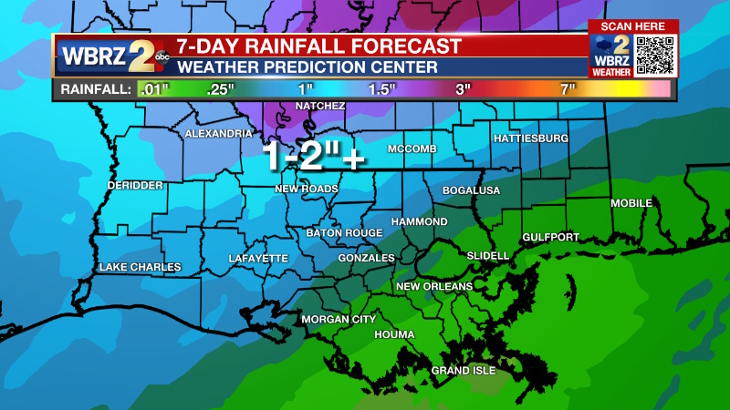
Up Next: By Thursday, the front will start to get a push through the area from northwest to southeast with another period of rain and thunderstorms. Additional rain of 1-2 inches is expected north and west of Baton Rouge with lighter amounts south and east. Though less than Sunday, since the ground is saturated and rivers are elevated, any heavier pockets around the Metro Area will need to be monitored for standing water issues and minor stream flooding. On Friday, the front will continue to move east of the area with gradually clearing skies and cooler, drier air. As sun returns, highs will stop in the upper 50s followed by a night of lows in the mid 30s. A dry and seasonable weekend is ahead.
Trending News
Get the latest 7-day forecast and real time weather updates HERE.
Watch live news HERE.
Detailed Forecast: The temperature forecast remains tricky. Wherever the nearly stationary front resides will denote the line that separates highs in the 50s to the north and highs in the 70s to the south. Within a few miles of the boundary, temperatures will be in the upper 50s and low 60s. Just a 20-30 mile shift in the front could change temperatures by 10 degrees, so especially in the I-10/12 corridor, be prepared for sharp temperature forecast adjustments. No organized rainfall is expected through Wednesday afternoon. In the evening hours, a weak upper level disturbance will come by, but is unlikely to create anything more than scattered showers north and west of Baton Rouge. An upper level trough of low pressure will swing across the southern third of the United States on Thursday giving the push needed to drive the front fully east of the area. In response to this passage, another batch of rain and thunderstorms is expected, albeit less significant than what occurred on Sunday. Still, since grounds are saturated and rivers are a bit high, any pockets higher than the inch or two that is forecast could cause some nuisance flooding issues and minor stream rises. Those maximum amounts are likely to happen northwest of the city, rather than where the heaviest rain fell on Sunday, which would be good news. Any shift to the south will be worth monitoring though. Everything will start to calm down on Friday with cooler and drier air moving in for the weekend. After a day of below average temperatures on Friday and Friday night, above average temperatures are expected for the weekend.
--Josh
The Storm Station is here for you, on every platform. Your weather updates can be found on News 2, wbrz.com, and the WBRZ WX App on your Apple or Android device. Follow WBRZ Weather on Facebook and Twitter for even more weather updates while you are on the go.
More News
