

Latest Weather Blog
TORNADO WATCH issued for I-10/12 corridor until 7am
A *TORNADO WATCH* has been issued for the entire WBRZ Weather Forecast Area, except St. Mary Parish, until 7am Saturday. The primary threats include a few tornadoes, and a couple intense tornadoes within the watch area, scattered damaging winds and isolated significant gusts to 80mph and isolated large hail events to 1.5 inches in diameter. As a slow-moving squall line intersects more discrete storms forming ahead of it, the tornado threat will increase. Otherwise, the squall line should intensify and accelerate with bowing segments capable of significant severe wind damage.
REMEMBER...A Tornado Watch means conditions are favorable for tornadoes and severe thunderstorms in and close to the watch area. If you are in these areas, be alert threatening weather conditions and listen for possible warnings.
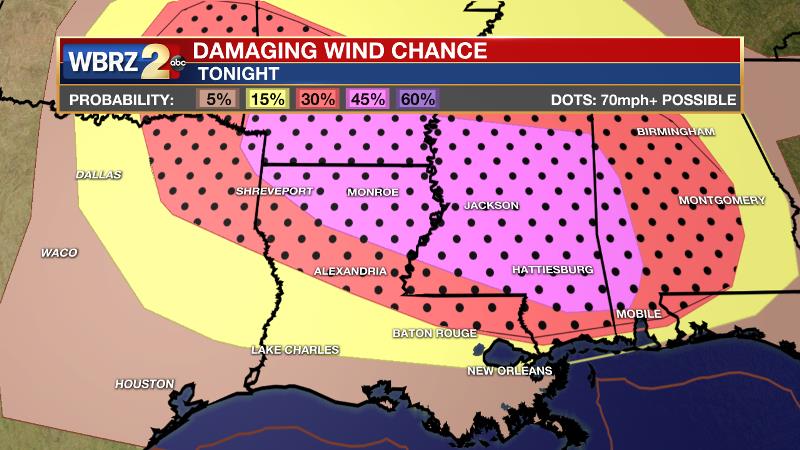
A strong upper level low pressure system will move across the Great Plains tonight with an associated cold front. Another impulse of energy in the upper levels will arrive just of those two main features. Locally, the atmosphere will be primed with lots of warmth and moisture ahead of the leading impulse, which will provide enough lift to spark isolated storm cells will have favorable low level winds to rotate and possibly produce a tornado. There is lower confidence on that possibility. There is higher confidence in what happens next. The main upper level trough and front will barrel across the region with a second batch of storms. Forecast models suggest a strong squall line will move through between midnight and daybreak on Saturday. By that time, ingredients will be favorable for damaging wind gusts and possibly large hail, with a lingering threat for an isolated tornado on the line. As for the damaging wind threat, the Storm Prediction Center has outlined a 15 to 30 percent chance of damaging wind (within 25 miles of a point on the map) across most of our area. North of I-12, some of the wind gusts could top 70mph. Additionally, the line could slow down closer to the I-10 corridor and cause street and poor drainage flooding could be an issue due to a period of torrential rain.
Trending News
Estimated Timeline:
- Begin: 1am Saturday
- Peak: 4-7am Saturday
- End: By Noon Saturday
Severe Weather Threats:
1) Damaging wind gusts over 58mph
2) Hail 1 to 2 inches in diameter
3) Isolated tornadoes
4) 2 to 4 inches of rain
Up Next: The weekend will begin with lingering showers and thunderstorms, but a cold front will push humidity southeast of the Baton Rouge area by Saturday afternoon. Rapid clearing is expected with sunshine in the afternoon. After highs in the upper 70s, a dry and clear night will send Sunday morning lows into the upper 50s. The second half of the weekend looks much nicer with sunshine and dry warmth that will last into Monday. A couple of fast moving fronts will deliver showers and thunderstorms again for the middle and end of next week. CLICK HERE for your full 7-Day Forecast.
Actions to Take Now:
Think about where you will be Friday night and Saturday morning and identify a structure that is central, low and away from windows. That is where you should go if a tornado or severe thunderstorm warning is issued. Mobile Home residents should find a nearby brick and mortar home of a family member or friend as it is recommended you prioritize the near term weather threat over social distancing. Go there as soon as a watch is issued, as you should still have plenty of time. Unfortunately, this storm system brings a threat while many are asleep so be sure to have access to alerts through the night.
You can download or activate the WBRZ WX App on your Apple or Android device or turn on a NOAA Weather Radio for bulletins such as watches and urgent warnings. Of course, the WBRZ Weather Team is here for you, on every platform. Your weather updates can be found on News 2, wbrz.com, and the WBRZ WX App. Follow WBRZ Weather on Facebook and Twitter for a constant stream of information. To review additional suggestion for severe weather safety, CLICK HERE.
More News
