

Latest Weather Blog
Sunday AM Forecast: Foggy start, more sunshine and heat for today
The forecast will be hot and humid today
THE FORECAST
Today & Tonight: Waking up this morning with temperatures in the mid-70s and some areas seeing reduced visibility. Fog will begin to lift across the area as the sun rises this morning. We will be left with a thin blanket of cloud cover for most of the morning hours. Temperatures will get on the steamy side today peaking near 92°. Typically with temperatures in the low 90s we would be watching heat index values. This heat is different, right now we have low humidity so temperatures will feel closer to their actual values. We still have some moisture in our atmosphere and that is why we will see some spotty showers in the afternoon hours. Overnight showers and clouds will be out of the area and temperatures will fall into the low-70s.
Up Next: Monday morning muggies will NOT be making a comeback this week. Fake fall is gone but the humidity will stay away for your workweek. Waking up with temperatures in the low-70s and mostly sunny skies. Monday morning we could see more fog development as we are expecting similar overnight conditions. Throughout the day there will be some fair weather clouds, but not expecting any rain in the forecast. With the low humidity temperatures will have plenty of opportunity to get on the steamy side, creeping well above average for this time of year. Temperatures will gradually get warmer throughout the week. For the rest of your workweek, expect more heat and less humidity in the forecast. Starting your day temperatures will be in the 70s, gradually rising into the low-90s throughout the day. Rain chances stay on the lower side for most of the week and humidity stays a little lower. Not quite fall yet… but drier conditions are expected for your workweek. Click here to see the 7-day forecast.
The Storm Station has you covered with hour-by-hour weather tracking is available for your location on the WBRZ WX App on your Apple or Android device. Follow WBRZ Weather on Facebook and Twitter for even more weather updates and unique weather insight from the whole team!
Trending News
In the Tropics:
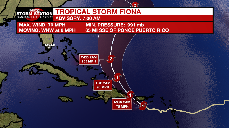
As of 8 am Sunday, Tropical Storm Fiona is approaching Puerto Rico with maximum sustained winds of 70mph. Moving west-northwest at 8mph, Fiona will continue on this track towards the northwest. Some gradual strengthening is expected today. Storm force winds and heavy rain are expected across the Leeward Islands, Virgin Islands, Puerto Rico and Hispaniola. The highest elevations of Puerto Rico could pick up about ten inches causing serious flooding.

Central Subtropical Atlantic:
Disorganized showers and thunderstorms continue over the central
subtropical Atlantic in association with a trough of low pressure.
Some slow development of this system is possible during the early or
middle part of this week while it moves generally northward,
remaining over the central Subtropical Atlantic.
* Formation chance through 48 hours...low...near 0 percent.
* Formation chance through 5 days...low...20 percent.
More News
