

Latest Weather Blog
TORNADO WATCH in effect, severe storms likely this afternoon & evening
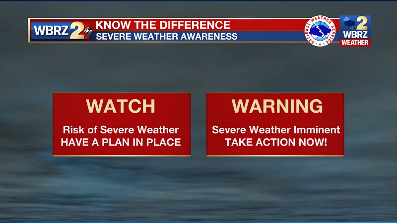
A TORNADO WATCH has been issued until 9PM. Conditions are favorable for severe thunderstorms, capable of producing tornadoes.
*TORNADO WATCH* for the shaded area. We're tracking storms and will bring you warnings if issued. #lawx #mswx pic.twitter.com/o902Omc8fc
— WBRZ Weather (@WBRZweather) March 30, 2022
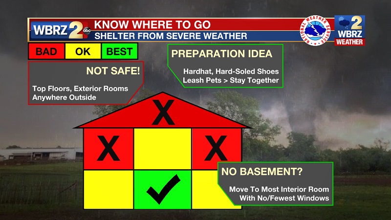
Remember your safe place - the lowest floor of a sturdy structure and away from windows. Grab pillows, blankets and even bike helmets to help protect yourself from flying debris in the event of a tornado. A mobile home or a car is NOT a safe place. If you are in a mobile home, stay with a friend or neighbor in a more sturdy structure until the storms pass later this evening.
Trending News
Wednesday: A High Wind Warning has been issued for all of South Louisiana ahead of afternoon storms. Winds will be sustained from 35-45mph+ and gusts at 55mph+. Be sure to secure any outdoor objects and tend to any weak tree branches. Know that winds of that magnitude can be enough to fall weak trees and powerlines so be ready for any related issues, even if you do not experience severe weather.
Temperatures will max out in the low-80s by early afternoon. Due to a very strong surface low pressure moving through the region, winds are expected to be quite strong through the day, even without any rain or thunderstorms.
.png)
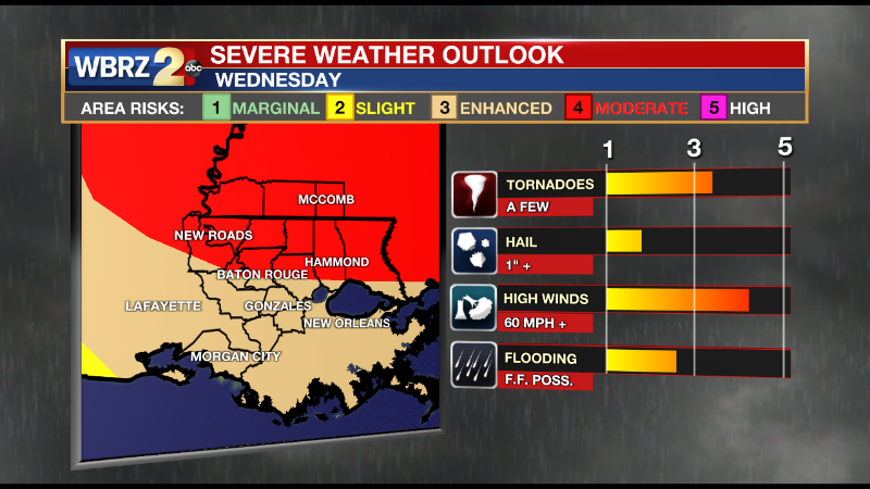
A fast-moving line of thunderstorms is expected primarily between 2pm – 6pm. The Baton Rouge area will be most active from 3-5pm. The Storm Prediction Center (SPC) has assigned a 4/5 “moderate risk” of severe weather north of I-12 with a 3/5 “enhanced risk” to the south. In this case, the time for severe weather should be limited to along and perhaps just ahead of the squall line—it will not be an all day event or all day washout. The biggest threat from these storms will be damaging wind gusts over 60mph. The SPC is even indicating a chance for wind gusts over hurricane force (74mph)! A brief tornado is also possible. While we could see a quick inch or so of rain, flooding is not a big concern, just some standing water in the usual nuisance spots. Skies will clear overnight into Thursday with a pair of mostly sunny and seasonable afternoons to close out the week. CLICK HERE for your detailed 7-Day Forecast.
Possible impacts of the HIGH WIND WARNING
Tropical Storm force winds 39 to 50 mph gusts to 65 mph: Minor damage will occur to many mobile homes. A few homes may receive mostly minor damage to roof shingles and siding.
- Unsecured lightweight items may become projectiles, causing additional damage.
- Some electrical wires will be blown down and local power outages are likely. Some weaker small trees and large branches may snap and bring down electrical lines resulting in power outages.
Possible wind impacts of SEVERE THUNDERSTORMS
Winds 50 to 60 mph gusts to 80 mph: Most mobile homes will experience moderate to substantial damage.
- Houses of poor to average construction will have damage to shingles, siding, and gutters.
- Some windows will be blown out.
- Unfastened home items of light to moderate weight will become airborne, causing additional damage and possible injury.
- Power outages will affect entire neighborhoods, especially in areas with numerous downed trees and power lines.
BOTTOM LINES:
*STRONG THUNDERSTORMS - possible Wednesday afternoon, limited to 2-4 hour window
*MAIN THREATS - damaging wind gusts over 60mph, isolated tornadoes possible
*GUSTY WIND - non-thunderstorms gusts up to 55mph possible all day, tie down loose objects
*BE WEATHER AWARE - charge mobile devices, have a way to receive alerts, know the safest place to go
SAFETY: Make sure you have a way to receive warnings in the event storms in your area turn severe. You can download or activate the WBRZ WX App on your Apple or Android device or turn on a NOAA Weather Radio for bulletins such as watches and urgent warnings. If a tornado warning or severe thunderstorm warning is issued, seek shelter in a low-level, interior room of a sturdy building. Take pets (on a leash) with you, have on hard-soled shoes, monitor storm coverage on a wireless device and cover your head in the event of wind or tornado impact. For more on tornado safety, CLICK HERE.
Reminder: With the threat for impactful weather, please have access to alerts through Wednesday. You can download or activate the WBRZ WX App on your Apple or Android device or turn on a NOAA Weather Radio for bulletins such as watches and urgent warnings. Of course, WBRZ, WBRZ+ and the Cable Weather Channel will have updates as active weather dictates.
More News
