

Latest Weather Blog
Round of storms tonight, stronger activity possible early weekend
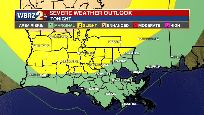
There are two periods to be weather aware through Saturday. A round of showers and thunderstorms will cross the area tonight with some potentially stronger activity Friday night into Saturday.
Next 24 Hours: A line, or cluster, of showers and thunderstorms will cross the area from northwest to southeast overnight between 11pm and 4am. Some of the thunderstorms could be strong with gusty wind and downpours but an isolated tornado is possible. Rain will be ending near daybreak with temperatures in the low 60s.
Partly sunny skies are anticipated on a much nicer afternoon with readings in the mid 80s. You may notice a little less humidity.
Trending News
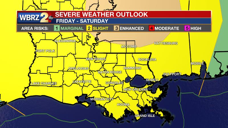
Up Next: Friday afternoon into Saturday morning, a strong upper level storm system and cold front will move into the region. Ingredients have started to look more favorable for severe weather and heavy rain. Threats will include gusty wind, hail and tornadoes. Including rainfall from tonight, much of the area could pick up 2-4 inches by Saturday night, which could cause street and poor drainage flooding. Most of Friday may be dry with high temperatures in the mid 80s. Action will increase into the night with multiple squalls possible into the first half of Saturday. Unsettled weather will break for some sun on Sunday and Monday but temperatures will stay above average. CLICK HERE for your full 7-Day Forecast.
The Explanation: Tonight, a cold front will move into the Arklatex region with an ongoing round of showers and thunderstorms. This activity is expected to race ahead of the boundary but should maintain enough integrity to produce scattered to widespread showers and thunderstorms overnight. While the SPC added a “slight risk” of severe weather for Baton Rouge and areas northwest, the nighttime arrival and loss of forcing away from the front should preclude a significant threat. Still, gusty wind and downpours can be expected and an isolated tornado is possible. Activity should end around dawn. The cold front will stall and/or washout north of the area but some drier air the atmosphere will result in 24-36 hours of quiet weather Thursday into Friday. A vigorous upper level trough will then push into the Midwest on Friday and drive another cold front to the southeast. Scattered to widespread showers and thunderstorms will fire up Friday evening and may continue via multiple rounds into Saturday morning. A disturbance just ahead of the main upper level trough and front could contribute to round one on Friday evening followed by another Saturday, likely early, as the front pushes through. Both instability and wind shear look to be sufficient for severe weather so gusty wind, hail and tornadoes are currently on the table.
Additionally, very rich moisture in the atmosphere will allow downpours. The fact that a couple of rounds could occur, some street and poor drainage flooding is possible. Forecast models and the Weather Prediction Center all agree on a range of 2-4 inches, with locally higher amounts, across the forecast area through Saturday. Sunday and Monday will feature improved weather with dry, sinking air taking hold. Through the early next week, expect above average temperatures with highs in the 80s and lows in the 60s. Another front will likely pass through the area early next week with another chance of showers and thunderstorms.
--Josh
The WBRZ Weather Team is here for you, on every platform. Your weather updates can be found on News 2, wbrz.com, and the WBRZ WX App on your Apple or Android device. Follow WBRZ Weather on Facebook and Twitter for even more weather updates while you are on the go.
More News
