

Latest Weather Blog
One more round of storms on Thursday
There is a 2/5 "slight risk" for severe weather on Thursday. A surface low and cold front will push through the area on Thursday. This system will bring one last round of showers and thunderstorms to the area. The ingredients will be favorable for an isolated strong thunderstorm, but the track of the surface low well north and west of the area may help to keep most action on the tame side.
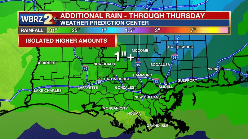
Expect additional rainfall of about one inch with isolated higher amounts. Thanks to the runoff from Tuesday and Wednesday, area rivers are rising. Keep in mind, it is common for smaller area rivers to go above flood stage every year and we should not draw comparisons to past events. Those living on the banks of the Comite, Tangipahoa and Tickfaw should make the usual preparations.
Trending News
RIVER UPDATE 5am Thursday
The Tangipahoa River at Robert is forecast to be in minor flood stage by the end of the week.
|
RIVER |
LOCATION |
CURRENT LEVEL |
FLOOD STAGE |
FORECAST |
|
Amite |
Denham Springs |
24.7’ |
29’ |
26’ by 4am Sat. |
|
Bayou Manchac |
5.4’ |
9’ |
7.8’ by 4am Mon. |
|
|
Port Vincent |
4.5’ |
8’ |
6.4’ by 4am Mon. |
|
|
French Settlement |
3.2’ |
4’ |
------ |
|
|
Comite |
Joor Road |
10.4’ |
20’ |
Cresting |
|
Tickfaw |
Liverpool |
5.9’ |
9’ |
Cresting |
|
Montpelier |
8.4’ |
13’ |
9.7’ by 4am Fri. |
|
|
Holden |
7.2’ |
15’ |
9.8’ by 4pm Fri. |
|
|
Natalbany |
Baptist |
8.2’ |
16’ |
Cresting |
|
Tangipahoa |
Amite |
8.9’ |
21’ |
Cresting |
|
Robert |
15.4’ |
15’ |
16.5’ by 7pm Thu. |
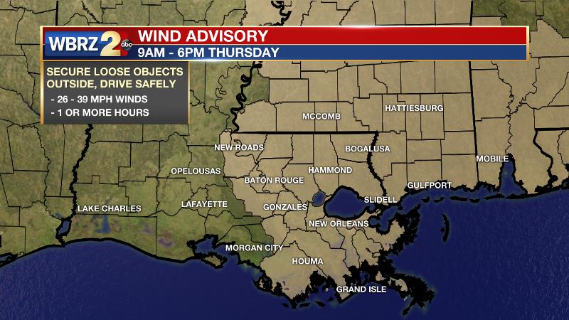
Today: Temperatures will run into the upper 70s early Thursday before a cold front moves in from the west. The front is expected to bring a round of rain and thunderstorms across the area. While the ingredients are favorable for some storms to turn severe, high resolution models that simulate radar do not look very impressive. Strong or not, the showers and thunderstorms will likely roll through between 10am - 4pm. If any storms act up, gusty wind and hail are the main threats. Regardless of rain and thunderstorms, Thursday will also be quite breezy with southwest winds of 15-20mph and some gusts up to 40mph possible. A WIND ADVISORY will be in effect from 9am - 6pm.
Up Next: Once the cold front makes it through, the area will dry out as low temperatures dip back into the 50s by Friday morning.The workweek will end on a quieter note with some sun and highs near 80 degrees. Another frontal system is pegged for the weekend. Right now, an area of showers and thunderstorms is possible late Saturday into Sunday, but the entire weekend does not look like a washout. CLICK HERE for your full 7-Day Forecast.
Remember that the WBRZ WX App. is *free* on Apple or Android devices and can be used for breaking weather information, live radar, as well as daily and hourly forecast details. You can also use it to watch live coverage if power or broadcast signal is ever lost. For even more, plug into the WBRZ Weather Team on Twitter and Facebook.
More News
