

Latest Weather Blog
Monday PM Forecast: time to dry
Alas, some change is occurring in the local weather that does not involve rain or humidity. After Tuesday, daily rain coverage will slip to near zero for the rest of the week.
Next 24 Hours: Some clouds will linger overnight as low temperatures try to dip down to averages in the mid 60s. A partly sunny afternoon is ahead on Tuesday with high temperatures in the low 80s. Much less humidity will be felt. A stray shower is not out of the question, especially south and east of Baton Rouge.
Up Next: Through the end of the week, skies will be staying mostly clear. Drier and more comfortable conditions will prevail perhaps allowing saturated soils to dry out a bit. High temperatures will be in the low to mid 80s with low temperatures in the low to mid 60s. Over the weekend, sunny afternoons will allow gradually warming high temperatures with some mid to upper 80s by Sunday. The next cold front could reach the area by Monday with some showers and thunderstorms. CLICK HERE for your full 7-Day Forecast.
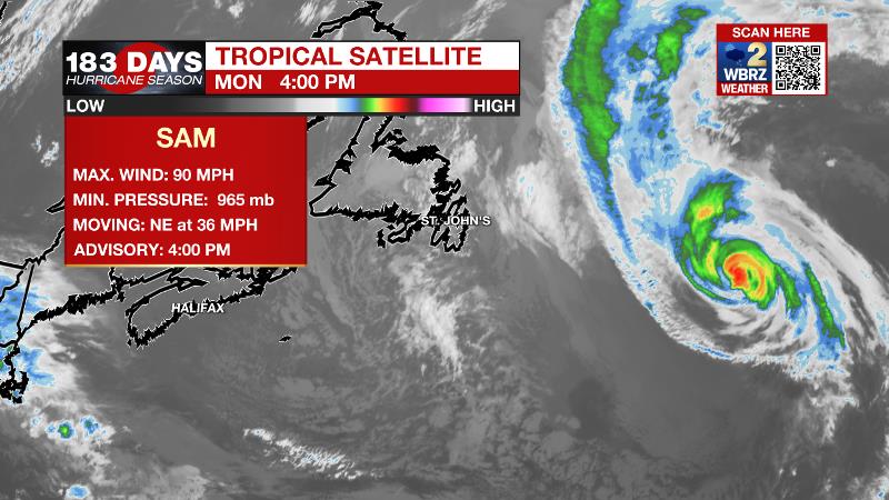
The Tropics: Hurricane Sam continues its impressive run, now in the North Atlantic. With maximum winds of 90mph, it will transition into a powerful post-tropical storm tonight. As of 4pm Monday, Sam has generated the 6th most energy of an storm since 1966. Fortunately, there has been virtually no impact to land. A large area of disorganized cloudiness and showers continues over the southeastern Bahamas in association with a surface trough. Thanks to unfavorable upper level winds, there is only a 10 percent chance of formation before the weekend. For the latest tropical forecasts, advisories and information, visit the WBRZ Hurricane Center as we navigate all 183 Days of Hurricane Season.
Trending News
The Explanation: An upper level shortwave trough will develop into an upper level low pressure system over the next few days. With the local area directly beneath the southern edge of the upper level low, drier air will win out to prevent widespread precipitation through Wednesday. With northerly winds behind a frontal passage, that drier air will mix through all layers of the atmosphere and result in a less humid air mass and lower low temperatures through the middle of the week as well. Many locations will reach seasonal averages in the low 60s. By Thursday, the upper level low will be replaced by an upper level ridge building in from the southwest. This feature will maintain a drier, warmer atmosphere with sinking air. The result will be a continued lack of precipitation with very few clouds and gradually warming temperatures. By the end of the weekend, lows will be in the mid to upper 60s with above average high temperatures in the mid to upper 80s. Another cold front will approach the area early next week.
--Josh
The WBRZ Weather Team is here for you, on every platform. Your weather updates can be found on News 2, wbrz.com, and the WBRZ WX App on your Apple or Android device. Follow WBRZ Weather on Facebook and Twitter for even more weather updates while you are on the go.
More News
