

Latest Weather Blog
Monday PM Forecast: The hot streak is broken with more rain on the way
The hot streak is officially broken.
THE FORECAST
Tonight & Tomorrow: Temperatures tonight will be in this mid-70s as any shower activity fizzles out. Tuesday temperatures will be in the low 90s with partly cloudy skies before more showers bubble up. About half of the area is expected to see rain. As the sun goes down, showers will fall apart, and it will dry out. Overnight temperatures will be in the mid-70s.
Up Next: A bit more rain in the extended forecast will help keep the temperatures down. Afternoon highs will reach the low 90s, but the afternoon hours will bring scattered showers. Not everyone will see rain every day, but there is a chance every afternoon. Rainfall totals for the week are coming in from 1-3 inches of much needed rain with isolated higher amounts. Higher totals will generally be closer to the coast. This amount of rain is manageable over a 7-day period. The Storm Station will continue to monitor for the risk of locally heavy rainfall. Click here to see the 7-day forecast.
Use the WBRZ WX App to keep tabs on the afternoon showers and storms. Hour-by-hour weather tracking is available for your location on the WBRZ WX App on your Apple or Android device. Follow WBRZ Weather on Facebook and Twitter for even more weather updates and unique weather insight from the whole team!
In the Tropics
Trending News
Potential Tropical Cyclone 2 has formed about 720 miles east of Trinidad. PTC 2 is forecast to become a tropical storm early tomorrow morning, and become the first hurricane of the season by late this week.
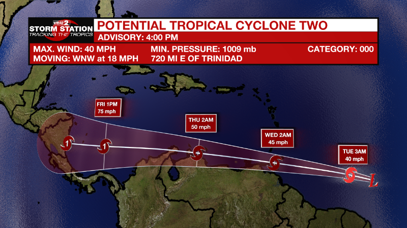
This system has been given the “potential tropical cyclone” name because its center is not yet completely organized, but the government of Trinidad and Tobago has issued a Tropical Storm Warning for Trinidad, Tobago, and Grenada and its dependencies. If/when this system organizes into a tropical storm, it will pick up the B name on the list, Bonnie.
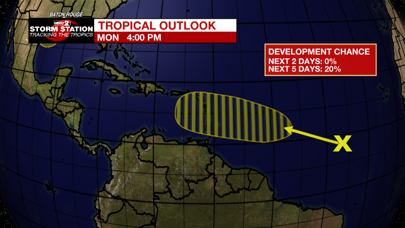
There are two other disturbances to watch. A disturbance in the Atlantic are going to travel west into the Caribbean but is unlikely to enter the Gulf. At this time, it is not expected to impact the local forecast. The other disturbance is going to contribute to a little extra rain this week. It is unlikely to develop into an organized tropical system, but we will see impacts in terms of rain in the next 5-7 days. A manageable 1-3 inches of rain is expected over the next week. We will be monitoring the risk for locally heavy rainfall.
Eastern Tropical Atlantic:
A tropical wave located several hundred miles southwest of the Cabo Verde Islands is producing disorganized showers and thunderstorms. Environmental conditions could become conducive for gradual development later this week while the system moves west- northwestward at around 15 mph over the central tropical Atlantic.
* Formation chance through 48 hours...low...near 0 percent.
* Formation chance through 5 days...low...20 percent.
.png)
Northern Gulf of Mexico:
Disorganized showers and thunderstorms over the north-central Gulf of Mexico are associated with a trough of low pressure. Development of this system is expected to be slow to occur while it moves west-southwestward at about 10 mph toward the northwestern Gulf of Mexico and approaches the coasts of southern Texas and northeastern Mexico during the next few days.
* Formation chance through 48 hours...low...10 percent.
* Formation chance through 5 days...low...20 percent.
More News
