

Latest Weather Blog
Into your weekend: fewer showers, higher heat
The number of showers and thunderstorms should tick down each day through Saturday. In the absence of rain, afternoons will be sultry.
Next 24 Hours: Isolated showers and thunderstorms will quickly diminish after sunset. Skies should become mostly clear. Another muggy overnight is expected with low temperatures in the mid 70s. Plenty of sun will be available through Thursday and will drive high temperatures in the low 90s. Combined with seasonably high humidity, the heat index will peak around 100 degrees during the afternoon hours. A stray shower or thunderstorm is possible, but most locations in the 13 Parish, 3 County Forecast Area should stay dry.
Up Next: Any showers or thunderstorms will be highly isolated Friday and Saturday. Just about all of the area should stay dry over that 48 hour stretch. Heat will be a bigger story with highs reaching the low 90s and feels-like temperatures in the low 100s—perhaps for several hours. Nights will not offer much relief as lows staying in the mid 70s. Onward from Sunday, enough instability and moisture should combine to add typical 30 to 40 percent rain chances across the board. CLICK HERE for your full 7-Day Forecast.
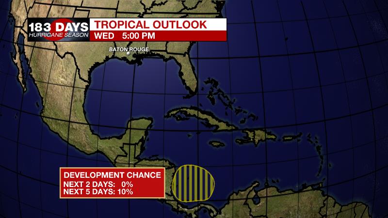
The Tropics: A broad trough of low pressure is expected to develop over the southwestern Caribbean Sea over the next few days. As the system moves slowly northwestward toward Central America, there is a 10 percent chance of tropical formation over the next 5 days. Be sure to visit the WBRZ Hurricane Center as we navigate all 183 Days of Hurricane Season.
Trending News
The Explanation: Beginning on Thursday, a strong upper level ridge over Mexico and the Central U.S. will start to broaden across the country. This will gradually bring a lowering of daily rain coverage through the end of the week and that trend will continue over the weekend as the ridge builds overhead. One caveat is that some forecast model guidance is hinting that a band of showers and thunderstorms that develops well north of our area, could swing into town Thursday afternoon. This could lead to an uptick in rain coverage north of I-10, but for now, we are holding on to a drier outlook. Of course, a lack of rain will push high temperatures back into the seasonably hot low 90s. By the end of the weekend, the ridge will shift slightly west and an upper level trough will dig into the eastern United States. The local area will sit between these two features in a persistent northerly steering flow. Additionally, forecast model guidance points to the axis of the eastern U.S. trough invigorating showers and thunderstorms, perhaps as far southwest as in our area, Sunday. For this reason, scattered showers and thunderstorms have been returned to the forecast for Sunday and beyond.
--Josh
The WBRZ Weather Team is here for you, on every platform. Your weather updates can be found on News 2, wbrz.com, and the WBRZ WX App on your Apple or Android device. Follow WBRZ Weather on Facebook and Twitter for even more weather updates while you are on the go.
More News
