

Latest Weather Blog
Frosty cold front to cross Louisiana this weekend
After a seasonable and sunny Friday, the coolest air of the fall season will arrive over the weekend.
THE FORECAST:
Today and Tonight: Friday Afternoon will once again reveal sunshine for the local area with high temperatures in the low 70s. Winds will be light and easterly. Take a jacket to any outdoor activity during the evening hours as thermometers will drop quickly after dark. Clouds will begin to increase overnight, which will hold thermometers a few degrees above average—in the low 50s. A shower is even possible by Saturday Morning.
Trending News
*FLOOD WARNING* continues for the Amite River at Denham Springs. The current level is 29.0’ which is at the flood stage. The river will crest at 29.5’ Friday Afternoon.
*FLOOD WARNING* continues for the Tangipahoa River at Robert. The current level is 17.5’ which is 2.5’ above flood stage. The river will fall below flood stage on Saturday.
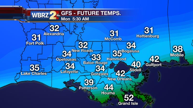
Looking Ahead: A cold front will push into the region on Saturday. Ahead of this boundary, highs will make it into the mid 60s. A few showers are possible, especially for areas south of I-10, but a washout is not expected. The headline with this front however, will be the chilly air that follows. After starting in the 40s, highs on Sunday will struggle to reach the low 50s despite plenty of sun. Then, into Monday, lows will fall into the low 30s. It now looks as though 32° will be possible for spots along and north of I-12. A frosty beginning is in the cards elsewhere. Some moderating will occur by the middle of the week.
THE SCIENCE:
Forecast Discussion: The next big trough will dive through the Great Lakes region and into the Southeastern United States on Saturday. A surface cold front will move into the region as well. Expect clouds to build up into Saturday Morning. The GFS forecast model has a dry passage with this front—believable as a very dry air mass is expected to be in place. The ECMWF model suggests a low pressure will stir up along the coast and produce a batch of rain. This typically reliable model stands alone in this regard, so we’ll carry an isolated rain mention for now, but we’re more inclined to the drier solution presented by the GFS. Either way, both models agree that this front will clear the region Saturday Evening, ushering in the coldest temperatures of the fall season thus far. While there may be some lag in the passage, Sunday Morning will still start off chilly, with highs only recovering into the 50s despite sun. The coldest temperatures will be reserved for Monday Morning. Individual model guidance and ensembles continue trending lower which seems to make sense given the clear skies, very dry air and decoupled lower troposphere that will present ideal cooling conditions. While the 30s are all but a certainty, a frost looks increasingly likely north of I-10 with a freeze possible north of I-12.
--Josh
Stay connected with me… share your thoughts!
Twitter: @Josh_Eachus
Google+: Josh Eachus
Facebook: Meteorologist Josh Eachus
More News
