

Latest Weather Blog
Front to approach the area tomorrow
Over the next 48 hours a cold front will slowly cross the region, maintaining scattered shower and thunderstorm possibilities until it does. The most likely period for widespread rain will be Thursday Afternoon and Evening.
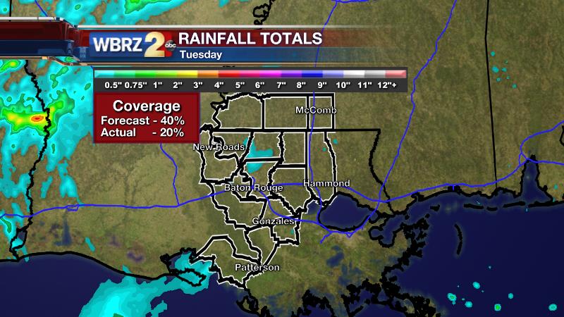
Tuesday indeed brought scattered showers—though they were very light, not amounting to anything for most. Only about 20 percent of the area saw measurable rainfall. Those locations were north and west of Baton Rouge as was forecast.
THE FORECAST:
Today and Tonight: Wednesday will be very similar to Tuesday with a few showers and thunderstorms, but not a washout. The chances to pick up measurable rain will be greatest during the afternoon hours. Highs will reach for 80 degrees with southerly winds of 5-10mph. Overnight, spotty showers should tend to shut down. Low temperatures will be in the mid 60s.
Trending News
Up Next: Thursday brings the best rain chances of the week with greater coverage across the forecast area. Some localized downpours will be possible. Highs will make it to the upper 70s during the afternoon hours. Areas of rain and storms may continue overnight as a front settles into the area. Lows will hold in the mid 60s. By Friday, showers will ease off with some returning sun in the afternoon. The weekend is shaping up to be warm, dry and mostly clear.
THE SCIENCE:
Forecast Discussion: While a shortwave trough works across the Midwest and Eastern United States through Thursday, ripples of vorticity will help to generate scattered showers and thunderstorms. On Wednesday, a moist profile will lend to the development of showers and thunderstorms. Activity should be fairly isolated until some better upper level energy arrives later in the day. By Thursday, not only will there be an area of vorticity but likely a weak front dropping southeastward through the region to enhance uplift. For that reason, this appears to be the most likely period for more widespread shower and thunderstorm activity. By this time, instability looks to be a bit higher with dew points in the upper 60s and precipitable water about 150% of normal. The upper wind profiles are not all that conducive to severe weather though, so heavy rain would be the main issue. There is some discrepancy as to how long the rain showers will hold on Friday. The GFS keeps action around through Friday while the ECMWF and GEM models bring everything to a close early in the day. The latter scenario seems more likely by a matter of model persistence of the last few days. Over the weekend, some weak ridging aloft should bring forth a trend of drying and warming. High temperatures will make it 4-7 degrees above average by Sunday with return flow kicking in by Monday to bring some humidity as well.
For updates, stay connected with Meteorologist Josh Eachus:
More News
