

Latest Weather Blog
Friday AM Forecast: Plenty of dry time before the afternoon showers, Tropics Update
The summertime pattern is here and it going to be sticking around throughout the weekend.
THE FORECAST
Today & Tonight: Waking up muggy this morning, but we are expecting plenty of dry time during the day today. Temperatures will get into the 90s today, but if you see a shower then you will get some relief from the heat. Afternoon showers will be popping in and out of the area today. Friday night plans will not be a total washout.
Be sure you download the WBRZ WX App so no pop-up showers catch you off-guard. Hour-by-hour weather tracking is available for your location on the WBRZ WX App on your Apple or Android device. Follow WBRZ Weather on Facebook and Twitter for even more weather updates and unique weather insight from the whole team!
Up Next: Plenty of sunshine and dry time expected as we head into the weekend. Saturday morning waking up to temperatures in the low 70s. Daytime highs will get into the 90s. If you see a shower you could get a quick break from the heat. Although the rain will be around all weekend, no day will be totally rainy. Most days will be dry and hot and then afternoon showers move in. Temperatures continue to rise into the mid 90s throughout the week. Click here to see the 7-day forecast.
Sun and Heat Safety: Some friendly reminders as the intense heat makes a comeback—sunburn can occur in less than 15 minutes with the extreme U.V. Index typical of this time of year. In addition to that, heat exhaustion and heat stroke can set in just as quickly. Seek medical attention if you or somebody you know is affected. While we all enjoy a list of cool beverages, be sure water is at least a part of that list! Finally, look before you lock. DO NOT leave people or pets in an unattended car.
Trending News
In the Tropics:
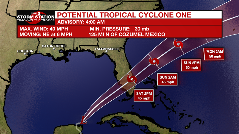
A tropical disturbance in the northwest Caribbean has a 90% chance of developing in the next two days. Regardless of development, this system is going to be a major rainmaker for the Yucatan Peninsula, parts of Cuba, and south Florida. It will move northeast and it is not expected to impact the local forecast.
For the North Atlantic...Caribbean Sea and the Gulf of Mexico:
Near the Yucatan Peninsula and the Southeastern Gulf of Mexico: The
National Hurricane Center is issuing advisories on Potential
Tropical Cyclone One, located near the northeastern portion of the
Yucatan Peninsula. The disturbance is expected to become a tropical
storm over the southeastern Gulf of Mexico later today.
* Formation chance through 48 hours...high...90 percent.
* Formation chance through 5 days...high...90 percent.
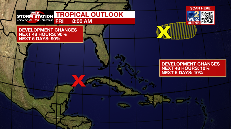
In the Western Atlantic west-southwest of Bermuda:
A small area of low pressure located more than 200 miles
west-southwest of Bermuda is producing a small area of showers and
thunderstorms. This system only has a brief window for further
development today before environmental conditions become
increasingly unfavorable by this weekend. This system is expected to
move generally eastward to the south of Bermuda.
* Formation chance through 48 hours...low...10 percent.
* Formation chance through 5 days...low...10 percent.
More News
