

Latest Weather Blog
FREEZE WARNING for entire area Thursday night
A *FREEZE WARNING* is in effect from 10pm to 8am tonight for Ascension, Assumption, East Baton Rouge, Iberville, Livingston, Pointe Coupee, St. James, St. Mary Parish, southern Tangipahoa and West Baton Rouge Parishes. Temperatures of 28-32 degrees are expected possibly killing crops and other sensitive vegetation. A *HARD FREEZE WARNING* is in effect for East Feliciana, northern Tangipahoa, St. Helena and West Feliciana Parishes, as well as Amite, Pike and Wilkinson counties. Temperatures as low as 25 degrees could also possibly damage outdoor plumbing. Remember to take the proper precautions and make sure people, pets and plants have access to warmth.
Next 24 Hours: Tonight, clear skies and light winds will allow thermometers to achieve maximum cooling potential and make it down to freezing in many neighborhoods, especially north of I-10. Locations north of Baton Rouge could spend a few hours in the upper 20s. This would mark the first freeze of the cool season for the city. Sunshine will persist on Friday allowing afternoon readings to climb about 25 degrees into the upper 50s. Winds will remain light and out of the northeast.
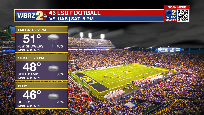
Up Next: A weak storm system will pass our area to the south on Saturday but could fling a few showers as far north as I-12. This activity will be much lighter than earlier in the week. Still, a damp, cloudy and chilly start to the weekend is expected. Plan for some intermittent, light rain showers if you are heading out to campus for tailgating or the game. Temperatures will hover around 50 degrees. A reinforcing front and north winds behind it will mean that temperatures will stay below average with highs in the 50s and lows in the 30s on Sunday and Monday. Temperatures will moderate a bit toward Thanksgiving, but a frontal system will also deliver some showers into the holiday. CLICK HERE for your detailed 7-Day Forecast.
The Tropics: For the North Atlantic, Caribbean Sea and Gulf of Mexico, all is quiet. No tropical development is expected over the next five days.
Trending News
The Explanation: A dry layer will extend further into the atmosphere Thursday night into Friday allowing clouds to break. Coupled with light, north winds, conditions will be favorable for radiational cooling and low temperatures will make it down to freezing with upper 20s possible in southwest Mississippi. Mostly sunny skies will allow temperatures to rebound into the mid 50s on Friday afternoon. A surface low pressure system will develop in the climatologically favorable region off the southeast Texas coast on Friday night. A warm front will form offshore and southwest winds aloft rounding the basin of a broad upper level trough still in place over the Eastern U.S. will result in a shield of precipitation forming. Increasing clouds and a few showers will be possible as far north as I-12 as this low tracks east across the Gulf of Mexico on Saturday. Most of southwest Mississippi will stay dry, a shower or two is possible around Metro Baton Rouge and a few showers are likely along the coast. After Saturday, the pattern will get a bit less active. The broad trough will finally de-amplify a bit and that will allow a warming trend as a surface high pressure system moves into the Eastern U.S. and sets up onshore flow next week. Thermometers may be closer to average by Thanksgiving as the next rainmaker moves into the region.
--Josh
The Storm Station is here for you, on every platform. Your weather updates can be found on News 2, wbrz.com, and the WBRZ WX App on your Apple or Android device. Follow WBRZ Weather on Facebook and Twitter for even more weather updates while you are on the go.
More News
