

Latest Weather Blog
Busy hurricane season is not over yet
With 5 major hurricanes in the books, a storm weary United States coastline hopes that October will bring the historically expected downturn in tropical activity. However, it is much too soon to breathe a sigh of relief.

In 2017, storms have torn across the central and western Atlantic. In doing so, upwelling and heavy rain have somewhat cooled water temperatures. However, even after temperatures dropped due to Harvey, the Gulf of Mexico recovered and remains warm. Meanwhile, the unfettered Caribbean Sea is like a hot tub with sea surface temperatures as high as 88 degrees. The amount of ocean stored heat is off the charts. While sea surface temperatures and ocean heat content do not generate storms, they do greatly aid development and strengthening.

Trending News
Those very warm water temperatures are currently found in a region historically favorable for development this time of year. During the month of October, tropical storm origins tend to be in the southern Gulf of Mexico, western Caribbean Sea and western Atlantic Ocean. Stalled fronts and weak upper level disturbances interact with still warm sea surface temperatures to spin up storms. Significant hurricanes to strike the Gulf Coast during the month of October since 1950 include, Gladys, Irene, Isbell, Jerry, Wilma, and for Louisiana, Juan in 1985.
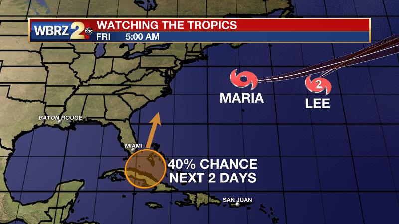
So, is anything brewing right now? The National Hurricane Center is monitoring a disturbance near Cuba which is given medium chance of development as it moves north over the next 2 days. This system will eventually pass east of Florida and encounter a harsher environment within the next week. Lee and Maria are weakening and moving out to sea. Nate is the next name on the storm list.

Way out in time, forecast models are suggesting some activity in the southern Gulf of Mexico or western Caribbean Sea late next week into the weekend. That time period is at the outer reaches of forecast model abilities and therefore comes with very low confidence. However, the signal from models is at least a reminder that hurricane season is not over, and that we need to stay alert and stay prepared. CLICK HERE to watch a video update.

The WBRZ Weather Team is here for you, on every platform. Your weather updates can be found on News 2, wbrz.com, Facebook, Twitter and the WBRZ WX App. on Apple and Android devices.
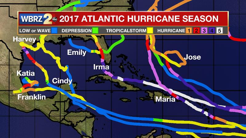
Of the 13 named storms and 8 hurricanes, 7 storms have made landfall. For just the sixth time, two category five hurricanes made landfall. Harvey became the first major storm to make landfall since Wilma in 2005. Irma became the strongest hurricane ever recorded in the Atlantic Ocean. Above average activity was predicted by NOAA prior to the season.
More News
