

Latest Weather Blog
Better bet for showers
A cold front moving into the region will allow more coverage in showers and thunderstorms across the forecast area before activity breaks off as the week ends.
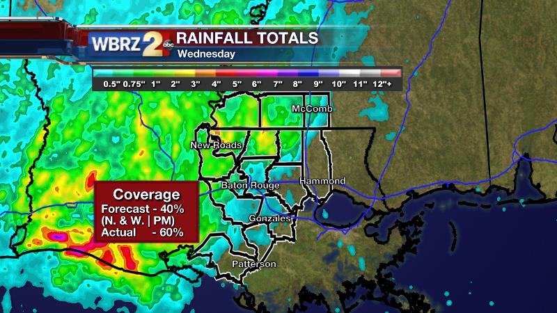
Wednesday brought the expected scattered showers and thunderstorms which were indeed limited to northern and western sections of the forecast area.
THE FORECAST:
Today and Tonight: Thursday brings the best rain chances of the week with greater coverage across the forecast area—especially during the afternoon and evening. Some localized downpours and gusty winds will be possible. One caveat to watch: a complex of rain and storms along the coast during the morning hours, may steal some energy available for development further north during the day. If this becomes the case, coverage and intensity will be lower. Highs will approach 80 degrees with some early sun expected prior to any precipitation. Areas of rain and storms will continue overnight as a cold front settles into the area. Lows will hold in the mid 60s.
Trending News
Up Next: By Friday, showers will end from north to south with some clearing possible later. Highs will climb into the low 80s. The weekend will start off in the low 60s with Saturday Afternoon brining mostly sunny skies and a warm 83 degrees. Sunday is looking mostly sunny as well with high temperatures a little warmer, getting into the mid 80s.
Meteorologist Josh Eachus discusses what may "shield" the area from widespread action later today and well above average temperatures in the near future:
THE SCIENCE:
Forecast Discussion: Alas, the stubborn and slow moving upper level low that has been parked over the Western United States is being absorbed by the jet stream and weakening. As this trough kicks to the northeast towards the Great Lakes region, its axis will guide a cold front toward the Louisiana Gulf Coast. Ahead of this front, moisture is pooling and the front will provide necessary uplift for showers and thunderstorms to develop. On top of this, as lobes of positive vorticity advection had been the culprit for development on Tuesday and Wednesday, another pocket of vorticity will enhance activity—especially Thursday Afternoon and Evening. The cold front will sink slowly southward on Friday ending precipitation from north to south through the morning. Some sun may break out, especially in northern areas by the afternoon. Over the weekend, a weak ridge will pass over the region Saturday leading to a mostly sunny and warm afternoon. Sunday is looking warm as well however forecast models are now all in agreement that a fast-moving shortwave will cross the area in the Sunday/Monday timeframe. A faster outcome would mean some showers need to be added to forecasts for the end of the weekend. Additionally, this wave is negatively oriented so may need to be monitored for the possibility of strong storms. This will be the main hiccup to monitor in the 7-day forecast. Warmer than average temperatures are anticipated through the middle of next week.
For updates, stay connected with Meteorologist Josh Eachus:
More News
