

Latest Weather Blog
Already drier, next much cooler
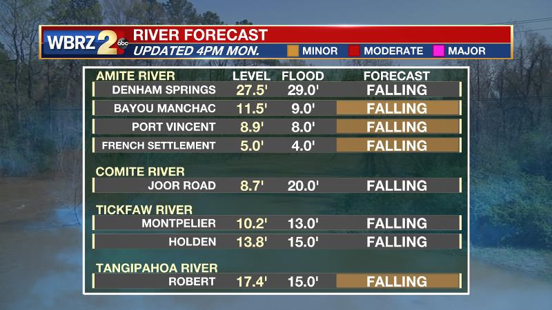
After collecting about a month’s worth of rain in 5 days, the region is getting a chance to dry out. All smaller, local rivers are expected to be below flood stage by Tuesday afternoon (more below).
Next 24 Hours: A weak disturbance will pass through the region tonight with an uptick in cloud cover. It is feasible this system could squeeze out some sprinkles, but highly unlikely that anything measures. Low temperatures will stop in the low 50s with generally light winds. After some clouds in the morning, Tuesday should be another glorious afternoon of blue sky and sunshine. High temperatures will make it into the mid 70s, just a little warmer than Monday.
Up Next: By Wednesday morning, a cold front will be through the area. This boundary will reinforce a dry air mass with cooler northerly winds. Thermometers will run about 10 degrees below average from Wednesday morning through Thursday afternoon. Skies will stay nice and mainly clear. A stronger storm system will cut across the southern third of the country Friday into Saturday. This one is expected to return showers and thunderstorms to the local area for about a 24-hour period. Fortunately, that will not allow for a long duration soak like the one we just experienced. It is too early to tell if severe weather could be any issue or not, so stay tuned. CLICK HERE for your full 7-Day Forecast.
The Explanation: A reinforcing cold front will pass through the area late Tuesday and a rather dry atmosphere will result in little more than passing clouds. Behind this boundary, temperatures will tumble well below average into Wednesday morning with lows in the 40s. By Thursday morning, persistent cold air advection and clear skies could allow some lows in the low 40s well north of I-12! Highs will range from the upper 60s to low 70s both days. By Friday and area of high pressure positioned northeast of the local area will return southerly winds and moisture to the atmosphere. The advance of this air mass will occur along a warm front Friday night with associated overrunning precipitation breaking out ahead of that in the afternoon hours. The associated cold front will run through by Saturday afternoon. The Storm Prediction Center is indicating that part of the area could be included in an outlook for severe weather Friday night into Saturday in the time period ahead of the cold front. Given some instability and moisture, and simply the time of year, this seems appropriate. We will have more details as the weekend gets closer. Another stretch of cooler, drier weather will follow for the end of next weekend and early next week.
Trending News
--Josh
The WBRZ Weather Team is here for you, on every platform. Your weather updates can be found on News 2, wbrz.com, and the WBRZ WX App on your Apple or Android device. Follow WBRZ Weather on Facebook and Twitter for even more weather updates while you are on the go.
More News
