

Latest Weather Blog
Tuesday evening video forecast
Related Story
Some fog will remain possible each morning through the remainder of the workweek with a few minor rain chances. More significant rain and thunderstorms are anticipated over a busy weekend.
End of the Week: morning fog, isolated afternoon showers, warm
Saturday: storms, mainly late
Sunday to Mardi Gras: seasonable and mainly clear

Tonight & Tomorrow: The nighttime hours will be partly cloudy and mild with lows in the upper 50s. A *DENSE FOG ADVISORY* is up once again for Wednesday morning, this time only including parishes south and east of Baton Rouge. Beyond morning fog and low clouds, Wednesday will be mostly cloudy with isolated light showers possible through the day. Other than occasionally swiping the windshield wipers or putting up an umbrella, this system will be low impact. Most will not even get rain. Also, the showers will do nothing to the unseasonable warmth with highs in the upper 70s again.
Rest of the Week: Thursday and Friday will also be much warmer than average, with highs in the upper 70s and low 80s and lows in the upper 50s. Both afternoons will feature a mix of sun and clouds. There is an outside shot at a brief shower on Thursday, while a little more sun is expected on Friday. The forecast bodes well for the LSU Baseball season opener on Friday afternoon—apply some sunscreen before going to the ballpark! The weekend games, especially Saturday, could be a different story.
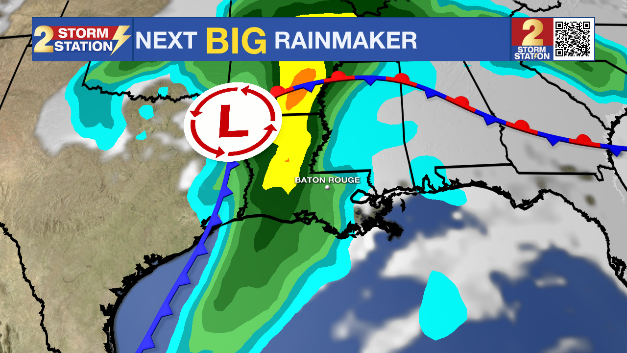
Saturday: The beginning of the weekend is a big one for the Red Stick. Between Valentine’s Day dates, the Spanish Town Mardi Gras Parade, and LSU Baseball’s opening weekend against Milwaukee, there is a lot happening outdoors. Not to be outdone, the weather will have a lot happening too, as a strong storm system is expected to move into the region during the late afternoon and into the night.
- The Spanish Town Parade: For the parade-goers in downtown, the midday hours look mostly cooperative with mostly cloudy skies and a few breaks of sun. Passing showers will be possible, but the stronger thunderstorms will wait until later, so at this time, there is no concern for safety. The warm temperatures will continue with temperatures in the upper 70s, and south winds of 10-20mph could make it a little tough to catch and hold those throws!
- LSU Baseball: Expect a muggy and breezy afternoon at Alex Box Stadium. During the game, afternoon high temperatures in the upper 70s will be met. Some sun may sneak through mostly cloudy skies, and a passing shower is possible, but there should be enough time to complete the game before heavy action arrives later.
- Date Night: The highest impact weather will occur during the evening and overnight hours—perhaps as many are out enjoying Valentine’s Day. A line of rain and thunderstorms is expected. While it is too early to pin down specifics, some of the storms could pack a punch. Be weather aware and take it easy if caught in heavy rain on the roads. Have a way to receive alerts while out and about to be safe from severe weather.
Sunday & Beyond: All rain should clear out by Sunday afternoon—if not earlier—leaving behind a more seasonable feel. Expect highs in the mid 60s with a lingering north breeze. Presidents' Day Monday will start cool in the mid 40s followed by full sun with a comfortable afternoon in the low 70s. Laissez les bons temps rouler as the pleasant weather continues into Mardi Gras.
Get the latest 7-day forecast and real-time weather updates HERE.
Watch live news HERE.
– Josh
The Storm Station is here for you, on every platform. Your weather updates can be found on News 2, wbrz.com, and the WBRZ WX App on your Apple or Android device. Follow WBRZ Weather on Facebook and X for even more weather updates while you are on the go.
News
