Wednesday PM Forecast: more fog and warmth
A *DENSE FOG ADVISORY* will be in effect from 9pm to 10am Thursday morning for the entire WBRZ Weather Forecast Area. Visibility could be as low as one quarter mile or less. Hazardous driving conditions due to low visibility should be expected.
Next 24 Hours: Skies will be mainly clear into the evening hours. With dew point temperatures in the upper 60s thanks to southerly winds, temperatures slowly dropping through the 70s into the 60s will result in air saturation and another round of fog near dawn. Thursday will be a continuation of the unseasonable warmth. As some sun works out into the afternoon hours, highs will top out in the low 80s again. A sprinkle or two is possible from any afternoon clouds thanks to the overabundance of moisture in the atmosphere for the time of year.
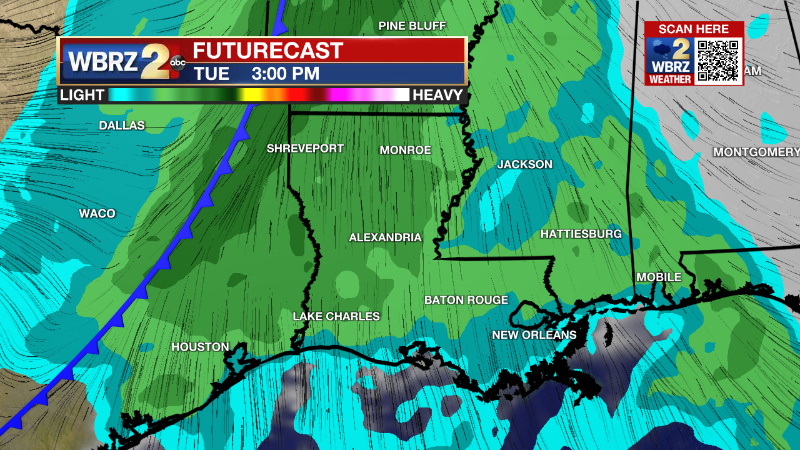
Up Next: Friday morning will be mild with low temperatures in the upper 60s. Patchy fog will remain possible. Friday afternoon will be partly sunny and rather warm with high temperatures topping out in the low 80s—especially in areas that receive the most sunshine. A weakening front will approach the area on Saturday causing increasing clouds and possibly a shower. This front will stall in the area resulting in isolated showers and temperatures in the mid 70s on Sunday. A strong front and better chance of rain and thunderstorms is expected next Tuesday and Wednesday, although confidence in the timing and specific impacts of that feature is currently low. Much colder air is expected to follow. CLICK HERE for your detailed 7-Day Forecast.
The Explanation: Fog potential will exists once again early Thursday as surface high pressure system well to our east supports continued onshore flow and a stable atmosphere. Mainly clear skies will result in temperatures cooling to the dew points and a thin layer of condensation producing lower visibility near the surface. Fog will quickly diminish on Thursday morning followed by a partly sunny and warm afternoon. The upper level ridge over the Gulf of Mexico, responsible for several days of well above average temperatures, will start to break down a bit into the weekend. A weak upper level trough of low pressure will pass by to the north, tamping it down a bit on Saturday. An associated cold front will be driven south but expect it to fall apart and lose its identity beneath the upper ridge. The remnants of this boundary could lead to a few showers over the weekend and especially on Sunday. Into early next week, a major storm system is expected to develop over the Mountain West as a deep, upper level trough digs into the Western U.S.

Trending News
A surface low will develop east of the Rockies and begin pushing eastward with an associated cold front. The upper level trough will send strong winds over the Mid-South and Gulf Coast. Meanwhile, the well established week-long onshore flow will have ample moisture in place. Bringing lift into the region in the form of a front will be enough to instigate widespread rain and potentially thunderstorms. With the surface low expected to stall well north of the region and the shape of the trough, the setup for severe weather is not ideal but enough ingredients will be in place to possibly overcome this. A clearer picture will become available over the next few days. Much cooler air is expected to follow the front to end next week.
It will stay unseasonably warm through the weekend. A strong cold front is expected to bring rain, thunderstorms and a significant drop next week. We'll do a deeper dive on @WBRZ tonight. pic.twitter.com/LhFwxTPD77
— Josh Eachus (@DrJoshWX) December 7, 2022
--Josh
The Storm Station is here for you, on every platform. Your weather updates can be found on News 2, wbrz.com, and the WBRZ WX App on your Apple or Android device. Follow WBRZ Weather on Facebook and Twitter for even more weather updates while you are on the go.


