

Latest Weather Blog
Tuesday PM Forecast: Quick afternoon showers, Watching the tropics
Showers quickly moving in and out this week.
THE FORECAST
Tonight & Tomorrow: As the sun begins to set we will see the showers begin to dissipate across the area. Temperatures will cool down into the low-70s, but the humidity is sticking around. Waking up Wednesday morning with some clouds in the sky. Temperatures will quickly warm into the low-90s throughout the day. If you see a shower earlier in the day then temperatures will not get as warm. Afternoon showers will be popping in and out of the area. Most people will stay completely dry, and if you do see a shower then it will be brief.
Up Next: The trend for this week is hot days with afternoon showers in the forecast. Most of the showers and activity will be quick pop-up and move out. Thursday evening into Friday morning a weak boundary moves through. Showers and storms are expected to remain isolated, but a brief heavy downpour is possible. Temperatures throughout the week will get into the low-90s with plenty of humidity making the heat index feel like the mid to high 90s. Overnight temperatures will be in the low 70s. Click here to see the 7-day forecast.
Be sure you download the WBRZ WX App so no pop-up showers catch you off-guard. Hour-by-hour weather tracking is available for your location on the WBRZ WX App on your Apple or Android device. Follow WBRZ Weather on Facebook and Twitter for even more weather updates and unique weather insight from the whole team!
Sun and Heat Safety: Some friendly reminders as the intense heat makes a comeback—sunburn can occur in less than 15 minutes with the extreme U.V. Index typical of this time of year. In addition to that, heat exhaustion and heat stroke can set in just as quickly. Seek medical attention if you or somebody you know is affected. While we all enjoy a list of cool beverages, be sure water is at least a part of that list! Finally, look before you lock. DO NOT leave people or pets in an unattended car.
Trending News
In the Tropics:
The remnants of Agatha have a 70% chance of redeveloping in the southern Gulf of Mexico late Thursday into early Friday. Regardless of development, this system is going to be a major rainmaker for the Yucatan Peninsula, parts of Cuba, and south Florida. It is not expected to impact the local forecast.
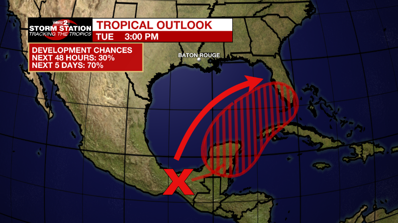
Near the Yucatan Peninsula and Southeastern Gulf of Mexico: A large and complex area of low pressure is expected to develop near the Yucatan Peninsula and the northwestern Caribbean Sea in a couple of days, partially related to the remnants of Agatha from the eastern Pacific. Despite strong upper-level winds over the area, this system is likely to become a tropical depression while it moves northeastward over the northwestern Caribbean Sea and southeastern Gulf of Mexico late Thursday or Friday. Regardless of development, locally heavy rainfall is likely across portions of southeastern Mexico, the Yucatan Peninsula, Guatemala, and Belize during the next couple of days, spreading across western Cuba, southern Florida, and the Florida Keys on Friday and Saturday. Interests in the Yucatan Peninsula, western Cuba, the Florida Keys and the Florida Peninsula should monitor the progress of this system.
* Formation chance through 48 hours...low...30 percent.
* Formation chance through 5 days...high...70 percent.
More News
