

Latest Weather Blog
Thursday PM Forecast: Well above average temperatures ahead
The upward trend in temperatures will continue through Sunday and highs could pop into the upper 80s before the weekend is over. The next appreciable chance for rain will follow on Monday.
Next 24 Hours: Those high clouds, that filtered out sunshine for part of our Thursday, will thin out and move east overnight. Temperatures will continue the trend of stopping a few degrees higher each day, and lows will bottom out in the mid to upper 40s. Skies are expected to stay mostly clear through Friday and continued lower humidity will cause a large range from low to high temperatures. Numbers will tick up a bit more to end the week with highs in the upper 70s.
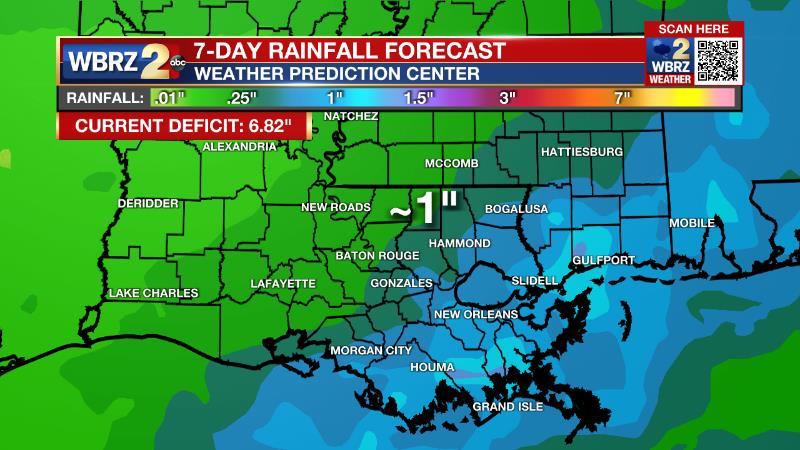
Up Next: Over the weekend, added moisture (higher dew points) will result in lows in the 50s and 60s with highs in the 80s. Sunday will be especially warm with high temperatures topping out in the mid 80s. If Metro Airport can reach 87 degrees, it will be the warmest temperature since October. Just 85 degrees would be good enough to tie a record high that dates back to 1945. An isolated shower or two could develop north and west of Baton Rouge on Sunday afternoon, but the better chance for area wide showers and thunderstorms will come with a slow moving cold front Monday into Tuesday. Cooler air will arrive behind this front but it appears enough moisture will linger on the backside to keep some showers around on Tuesday and Wednesday. While any rain will be considered beneficial in the current deficit, amounts are expected to be light over the three-day stretch. CLICK HERE for your detailed 7-Day Forecast.
The Explanation: By Friday, an upper level ridge will bridge the area while a surface high moves into the Southeast U.S. resulting in a gradual onshore flow. Temperatures will continue to nudge warmer but light winds will mean in a slower increase in dew point temperatures and changes may not be felt until Saturday. The slow to return moisture will result in very dry conditions and low relative humidity values through the end of the week. Over the weekend, the upper level ridge will migrate eastward setting up a deep southwesterly wind flow in the atmosphere. This will allow moisture to increase throughout the column when combined with onshore flow returning at the surface. Temperatures will climb 10-15 degrees above average. Despite the increased moisture, rain will be hard to come by in the absence of any significant triggering mechanism and so some shallow showers are all the will be possible mainly north and west of Baton Rouge. On Monday, a frontal system will begin to settle southward into the region. An upper level trough, still expected to pass well north of the region, is expected to be strong enough to push a cold front into and through the area. This feature will cause scattered showers and thunderstorms Monday. Cooler air will push in on Tuesday but the front will linger close enough to the coast that scattered showers will remain in the forecast Tuesday into Wednesday until a stronger upper level trough of low pressure swoops through on Wednesday forcing the front away.
Trending News
--Josh
The Storm Station is here for you, on every platform. Your weather updates can be found on News 2, wbrz.com, and the WBRZ WX App on your Apple or Android device. Follow WBRZ Weather on Facebook and Twitter for even more weather updates while you are on the go.
More News
