

Latest Weather Blog
Saturday PM Forecast: Record Broken - Overnight Warmth - More Heat Sunday
More record high temperatures could fall in the coming week.
THE FORECAST
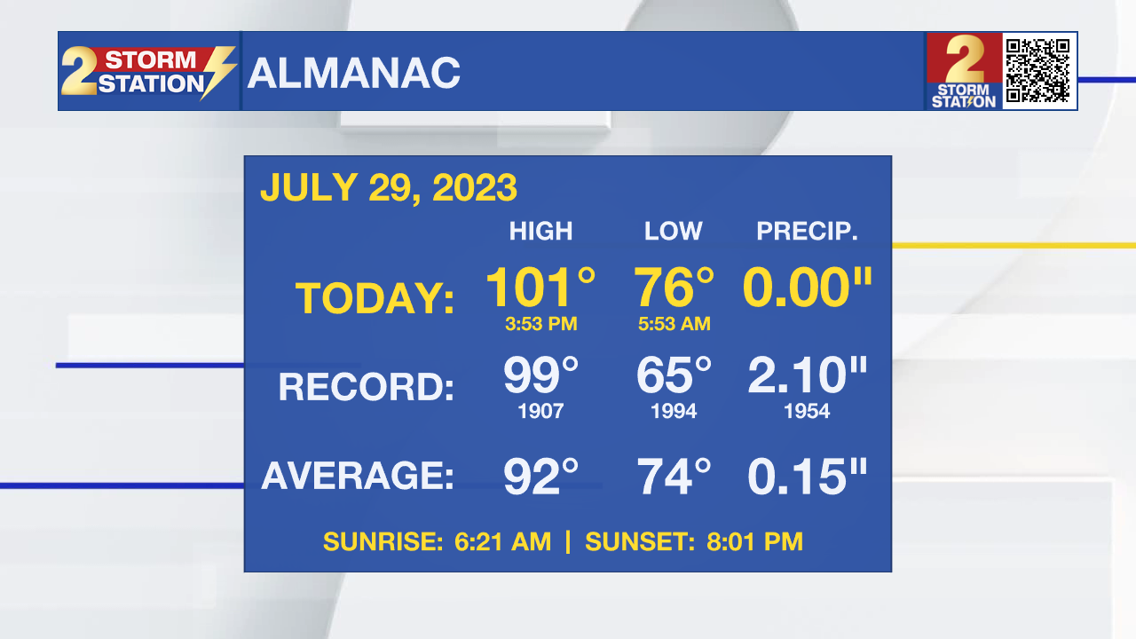
Tonight & Tomorrow: Baton Rouge hit 101° this afternoon breaking the old record of 99° set back in 1907 as the heat wave sends the heat index well into the 100s as air temperatures approach, and even surpass the triple digits. Overnight, skies will clear, and it will be a rinse and repeat for Sunday. Temperatures will start off in the upper-70s on Sunday morning, but quickly warm after the sun rises. Afternoon temperatures will quickly climb into the upper-90s as moisture from the Gulf of Mexico builds in over our area to force the dew points into the upper 70s, which will send the heat index soaring. Throughout the afternoon, expect feels like temperatures to reach the 110° range. A few spotty showers are possible Sunday afternoon, but these showers will not be enough to provide any measurable cool down.
A *HEAT ADVISORY* will be in effect on Saturday from 11am - 7pm for all of southeast Louisiana and southwest Mississippi. Heat index values up to 110 may cause heat illnesses to occur.
Drink plenty of fluids, stay in an air-conditioned room, stay out of the sun, and check up on relatives and neighbors. Young children and pets should never be left unattended in vehicles under any circumstances. Take extra precautions if you work or spend time outside. When possible, reschedule strenuous activities to early morning or evening. Know the signs and symptoms of heat exhaustion and heat stroke. Wear lightweight and loose fitting clothing when possible. To reduce risk during outdoor work, the Occupational Safety and Health Administration recommends scheduling frequent rest breaks in shaded or air conditioned environments. Anyone overcome by heat should be moved to a cool and shaded location. Heat stroke is an emergency!
Trending News
Up Next: Over the next several days, temperatures will continuously flirt with the 100° mark, and the feels like temperatures will be 10-15° warmer than the actual air temperature. Into the start of next week, the upper-level pattern will continue to strengthen as the high pressure "heat dome" ridge continues to build in. Rain chances will be minimal for the entire week. Click here to see the 7-day forecast.
The Storm Station has you covered with hour-by-hour weather tracking is available for your location on the WBRZ WX App on your Apple or Android device. Follow WBRZ Weather on Facebook and Twitter for even more weather updates and unique weather insight from the whole team!
In the Tropics: North Atlantic...Caribbean Sea and the Gulf of Mexico
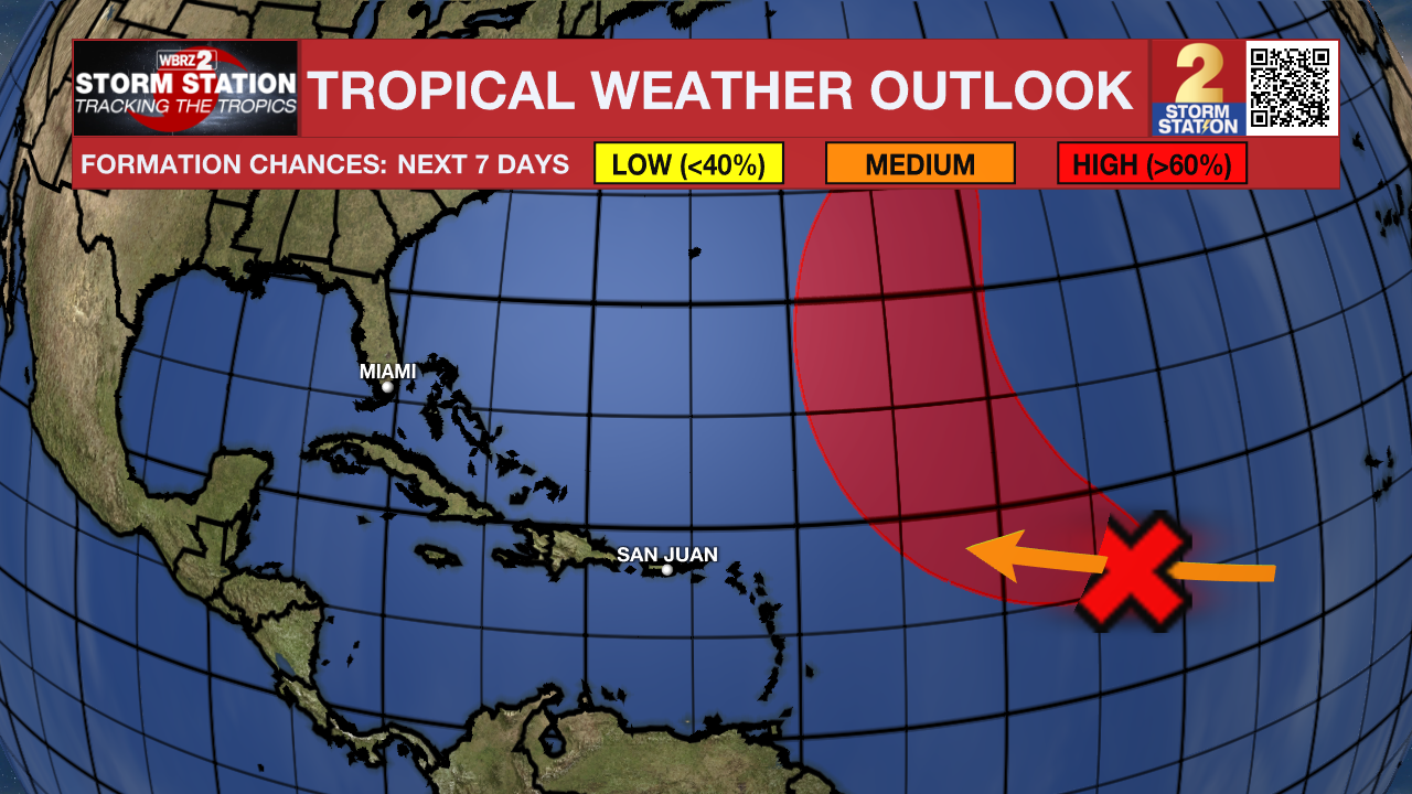
Central Tropical Atlantic: Disorganized cloudiness and showers located about 1100 east of the Leeward Island are associated with a tropical wave. Conditions are expected to be favorable for gradual development of this system during the next few days, and a tropical depression is likely to form during the early part of next week. The disturbance is forecast to move west-northwestward to northwestward at about 15 mph during during the day and then turn north-northwestward over the central subtropical Atlantic Monday and Tuesday. Formation chance through 48 hours is 20%, and formation chance through 7 days is 70%.
Get the latest 7-day forecast and real time weather updates HERE.
Watch live news HERE.
More News
