

Latest Weather Blog
Saturday PM Forecast: Bringing the heat AGAIN for tomorrow
Plenty of sunshine today, expecting more of the same for tomorrow.
THE FORECAST
Tonight & Tomorrow: For the most part shower and storm activity stayed along the coastline this afternoon. As the sun begins to set all shower activity will end across the Capital Area. Temperatures on the steamier side today in the low-90s. Overnight things will cool down a bit into the 70s but not expecting a cool/dry morning for tomorrow. Humidity made a return back into the forecast and we will be waking up feeling sticky with mostly sunny skies. Cloud cover builds in as temperatures heat into the low-90s tomorrow. Shower and storms are possible but more likely for the southern parts of our viewing area. I would not rule out a quick shower for our northern parts but not expecting a total washout for anyone tomorrow. Into the evening the little shower activity will settle down as the sun begins to set. Overnight temperatures will settle back into the 70s.
Up Next: Monday morning muggies will NOT be making a comeback this week. Fake fall is gone but the humidity will stay away at the start of the week. Waking up with temperatures in the low-70s and sunny skies. Throughout the day there will be some fair weather clouds, but not expecting any rain in the forecast. With the low humidity temperatures will have plenty of opportunity to get on the steamy side, creeping well above average for this time of year. Temperatures will gradually get warmer throughout the week. For the rest of your workweek, expect more heat and less humidity in the forecast. Starting your day temperatures will be in the 70s, gradually rising into the low-90s throughout the day. Rain chances stay on the lower side for most of the week and humidity stays a little lower. Not quite fall yet… but drier conditions are expected for your workweek. Click here to see the 7-day forecast.
Need a game day forecast? The Storm Station has you covered with hour-by-hour weather tracking is available for your location on the WBRZ WX App on your Apple or Android device. Follow WBRZ Weather on Facebook and Twitter for even more weather updates and unique weather insight from the whole team!
Trending News
In the Tropics:
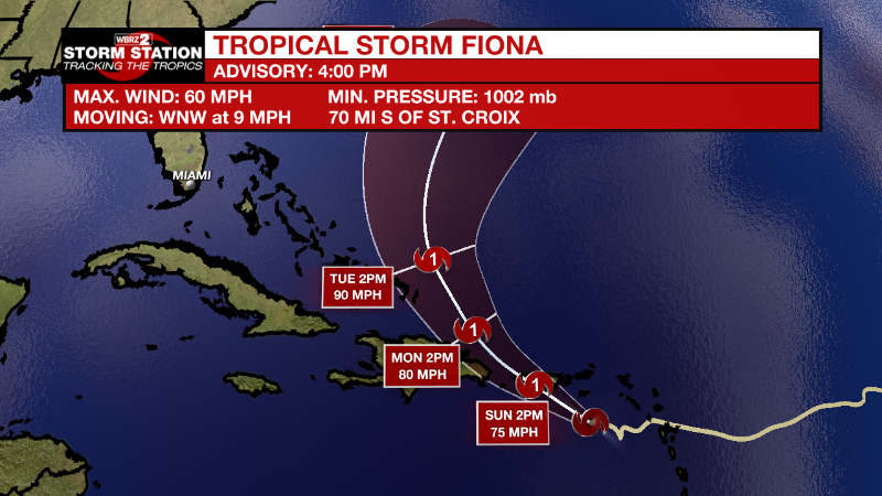
As of 4 pm Saturday, Tropical Storm Fiona is approaching Puerto Rico and the Virgin Islands with maximum sustained winds of 60mph. Moving west-northwest at 9mph, Fiona will continue on this track but slow down over the weekend before turning west-northwest early next week. Some gradual strengthening is possible. Storm force winds and heavy rain are expected across the Leeward Islands, Virgin Islands, Puerto Rico and Hispaniola. The highest elevations of Puerto Rico could pick up about ten inches causing serious flooding.
Central Subtropical Atlantic:
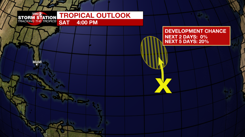
Disorganized showers and thunderstorms over the central subtropical
Atlantic are associated with a trough of low pressure. Some slow
development of this system is possible during the early or middle
part of next week while it moves generally northward at about 10
mph.
* Formation chance through 48 hours...low...near 0 percent.
* Formation chance through 5 days...low...20 percent.
More News
