

Latest Weather Blog
Rivers crest above flood stage after near-record wet stretch
The new year is picking up where 2016 left off—wet. So far, the Baton Rouge area is running a 5.57 inch surplus in the rain gauges on the heels of one of the wettest stretches in January history.
6.65 inches fell from January 19-22. However, the three-day span from January 19-21 ranks third all-time for total rainfall over three straight days in January.
The number one spot belongs to January 1993 when 9.02 inches of rain fell from the 19th to 21st. Remarkably, 9.01 inches from that benchmark belong to January 20, 1993—the wettest single day in January history.
With 9.59 inches, we are amidst the fourth wettest beginning to a year on record. Only 1993, 2013 and 1998, (with over 14 inches) had more rain through January 23. 2017 currently ranks as the 9th wettest January for the Baton Rouge area. Very little rain is expected for the remainder of the month. If passing rain showers can produce more than 0.35 inches of rain on Wednesday, January 2017 could climb as high at the fifth wettest on record.
There are several locations in Southeast Louisiana that have registered more rain than Baton Rouge so far in 2017:
|
BROWNFIELDS |
13.38” |
|
DENHAM SPRINGS |
11.98” |
|
SLIDELL |
11.23” |
|
JACKSON |
11.04” |
|
DONALDSONVILLE |
10.92” |
|
COVINGTON |
10.56” |
|
MT. HERMON |
10.3” |
|
SUN |
10.21” |
|
NORWOOD |
10.18” |
|
TERRYTOWN |
9.74” |
Staggering as these number may be, other regional locations have registered much more rain through the first 22 days of the year. Each in the top 10 list comes from 1998 or 2013.
|
NEW ORLEANS |
18.04 |
1998 |
|
BATON ROUGE (CONCORD) |
17.69 |
2013 |
|
DONALDSONVILLE |
17.24 |
1998 |
|
BAYOU SORREL |
17.12 |
2013 |
|
CONVENT |
17.08 |
1998 |
|
LSU |
17.02 |
2013 |
|
THIBODAUX |
16.85 |
1998 |
|
SLIDELL |
16.57 |
1998 |
|
SUN |
16.51 |
1998 |
|
LUTCHER |
16.49 |
1998 |
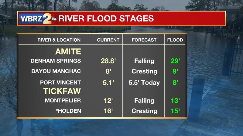
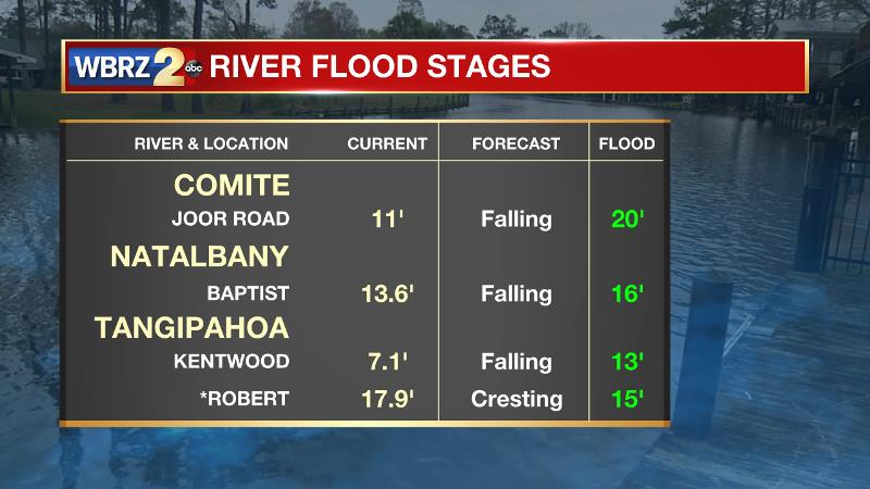
Due to the rain surplus, some area rivers have caused minor flooding. The Amite at Denham Spring, the Comite at Joor Road, the Tickfaw at Holden and Montpelier and the Tangipahoa at Robert have all crested above flood stage and are now falling. See the images below for the latest levels as of 9am Monday.
*All Baton Rouge data collected from Baton Rouge Metropolitan Airport. Records date back to 1930.
For real time weather information and the latest forecasts stick with the WBRZ Weather Team on Facebook and Twitter.
More News
