

Latest Weather Blog
Phil's call on the ball? Or is Pierre's guess the best?
We have made a significant change to the temperature forecast on the other side of a cold front moving through the region. A modest cool down now seems likely.
THE FORECAST:
Today through Tomorrow: As a weak cold front settles into the area, mainly cloudy skies are expected for Thursday with high temperature still making it into the mid 70s. While an isolated shower is possible, any precipitation that occurs will be light. The overnight hours will have continued cloud cover and spotty showers. Lows will bottom out in the mid 50s.
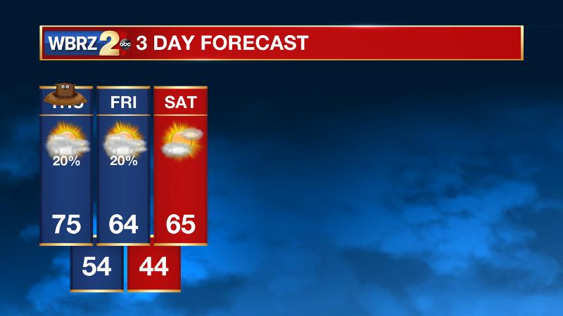
Up Next: The slow moving cold front is expected to be midway through the forecast area on Friday resulting in mostly cloudy skies and a few showers, especially early. Although initial thoughts were that milder air would prevail beyond the front, it now appears as though thermometers will hold in the mid 60s. Saturday will begin in the mid 40s. With more sunshine breaking out in the afternoon, highs will make it into the mid 60s. On Sunday, clouds will thicken and isolated showers will once again be possible. It won’t be a washout, so aside from dodging a brief pocket of rain, outdoor plans should be fine. Highs will be near 70 degrees. Early next week will feature quiet weather and above average temperatures
Trending News
Looking Ahead: Often times Punxsutawney Phil misses the call, and by seeing his shadow and predicting more winter this year, he may be off again—at least in our area. The Climate Prediction Center is looking for above average temperatures across the Southern United States for the month of February. That certainly would suggest a spring-like feel for the final month of meteorological winter.
THE SCIENCE: A weak cold front is settling south toward the Gulf Coast and running parallel to a fast zonal flow aloft. Deep layer moisture and omega are lacking with the front which does not present a sharp temperature gradient either. However, gradual ascent due to the front will be enough to increase low cloud cover and provide a low chance for showers through Friday. Over the weekend, the stalled front will be given a push away from the area thanks to a weak, fast moving disturbance in the upper levels. This feature may in fact have a better chance of producing showers than the front to end this week. Temperatures will not change much, however a brief drop off is possible on Saturday. Into next week, the mild air continues before a deeper trough begins digging into the southeast United States. This trough axis will pass over the forecast area and bring a better chance for showers and thunderstorms. A trailing cold front being advanced southward by a Canadian based surface high may brig below average temperatures to end next week.
--Josh
Related Stories
More News
