

Latest Weather Blog
One more dry day before tropical showers arrive
One more nice day is ahead before our area begins feeling the effects of a tropical system. While the “designation” of the system is still unclear, a period of rainy weather is the main concern this weekend.
Next 24 Hours: A mainly dry day will transition into a clear and mild night for the time of year. Low temperatures will stop near 70 degrees and some upper 60s are even possible north of I-12. Thursday will be another mainly sunny afternoon with highs in the low to mid 90s. The feels-like temperatures should remain in check, in the upper 90s, due to the air remaining slightly drier by June standards.
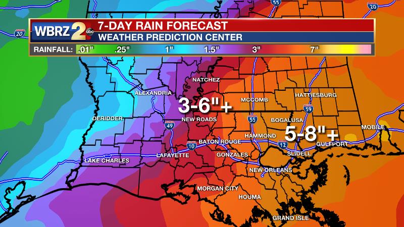
Up Next: All eyes turn to the south by Friday. Regardless of an officially named storm, a lot of tropical moisture will move over the area. Periods of rain can be expected Friday afternoon through Sunday afternoon. Saturday will be the wettest part of the forecast period. As is the nature of tropical rain, it could be torrential at times. The current expectation is for about 3 to 6 inches of rain, but isolated amounts up to 10 inches will be possible. The highest amounts should be east of I-55 with the lowest amounts west of the Mississippi River. The track and intensity of this system, while still unclear, is a bit less important than usual because confidence is high that rain will be the primary issue with this system and that it will occur well east of wherever a “center” passes. There could be coastal flooding and higher tides in usual trouble spots. If you live in the Baton Rouge area, continue to get weather updates into the weekend. CLICK HERE for your full 7-Day Forecast.
The Tropics: Disorganized showers and thunderstorms continue over the Bay of Campeche and southern Mexico in association with a broad area of low pressure. This system will move little through tonight and little, if any, development is expected during that time due to interactions with land. However, the system should begin to move northward on Thursday, and a tropical depression is likely to form by late Thursday or on Friday when the low moves across the western Gulf of Mexico. Hurricane Hunters will fly into this system on Thursday. For the latest forecast and preparation reminders, visit the WBRZ Hurricane Center as we navigate all 183 Days of Hurricane Season.
Trending News
The Explanation: An unseasonably dry air mass will maintain mostly clear skies and slightly lower than average humidity through Thursday. Into Friday, all forecast focus is on the tropics. Confidence is lower in the eventual track or strength of a tropical system. However, confidence is higher that the eventual evolution of this system will result in a period of wet weather. By Friday, bands of showers and thunderstorms will pinwheel across the area in response to increased moisture and lift in the environment on the northern fringes of the tropical disturbance. With substantial instability in place as well, isolated tornadoes may also spin up throughout the night and into Saturday. It is possible, if not likely, that where the center of this storm moves over land will stay mainly dry while a swath of heavier rain is displaced well east of that. Periods of rain related to the system will stay in the forecast through at least Sunday morning. With near record moisture content in the atmosphere, rain could be very heavy at times and forecast models are pointing to 3 inches on the conservative end and 8 inches on the aggressive side. The official Weather Prediction Center rainfall forecast is for 3 to 6 inches of rain for areas north and west of Baton Rouge and 5 to 8 inches south and east. By Sunday, the system will begin to pull away to the northeast and the threat for heavy rain will start to diminish. However, showers and thunderstorms will stay in the forecast well into next week as a weak front stalls across the I-20 corridor serving as a trigger for activity.
--Josh
The WBRZ Weather Team is here for you, on every platform. Your weather updates can be found on News 2, wbrz.com, and the WBRZ WX App on your Apple or Android device. Follow WBRZ Weather on Facebook and Twitter for even more weather updates while you are on the go.
More News
