

Latest Weather Blog
Monday PM Forecast: warm ahead of early weekend cold front
Another warm week is ahead. However, if you have been waiting for a cold front to bring more fall-like temperatures—that is expected by the weekend.
Next 24 Hours: Clouds will thin out overnight due to some drying in the atmosphere. Low temperatures will remain muggy in the low 70s. On Tuesday, a bit more sunshine will be available compared to Monday. High temperatures will be in the upper 80s with lighter, south winds.
Up Next: Wednesday and Thursday will bring more of the same. Skies will remain mostly clear with just a stray, light, afternoon shower possible either day. Warm and sticky conditions will prevail with highs in the upper 80s and lows in the upper 60s and low 70s. A cold front will work into the region on Friday. Another warm afternoon is on tap for Friday as a cold front approaches the area. This system could stir up some showers and thunderstorms and the currently anticipated timing suggests those with evening high school football plans should stay in touch. Rain will end from west to east around daybreak Saturday as the front exits. Northerly winds will push away any sensible humidity and highs will then stay in the 70s for a few days. Overnight lows will be in the 50s for at least Sunday and Monday. CLICK HERE for your full 7-Day Forecast.
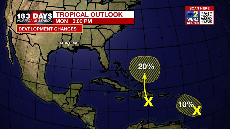
The Tropics: A tropical wave east of the Windward Islands has just a 10 percent chance of development over the next few days due to strong upper level winds. Another tropical wave south of Hispaniola has a 20 percent chance of gradual development as it nears the Bahamas later this week. For the latest tropical forecasts, advisories and information, visit the WBRZ Hurricane Center as we navigate all 183 Days of Hurricane Season.
Trending News
The Explanation: A weak front will stall and dissipate north of the local area on Tuesday. Given this, no major changes are expected to surface conditions with above average temperatures and humidity for the time of year. In the upper levels, the main feature for the central Gulf Coast will be a ridge pinched between a trough off the East Coast and a deepening upper level trough over the Mountain West. Subsidence associated with the ridge will provide a few more days of mainly dry weather with highs in the upper 80s and lows in the low 70s. The upper level trough out west will begin the break east with an associated surface storm system by Thursday. Hurricane Pamela, in the Pacific, will help to deepen the upper level low and weaken the ridge over the local area. These features will ensure that the cold pool is deep enough to push a cold front through the local area Friday into Saturday. Days of southerly flow should leave enough moisture established for the front to trigger isolated to scattered showers and thunderstorms late Friday. Since the boundary will be progressive, there will likely only be about a 6-12 hour window for precipitation. Behind the front, northerly winds will send moisture out of the area and temperatures below average. Expect highs in the mid to upper 70s and lows in the low to mid 50s.
--Josh
The WBRZ Weather Team is here for you, on every platform. Your weather updates can be found on News 2, wbrz.com, and the WBRZ WX App on your Apple or Android device. Follow WBRZ Weather on Facebook and Twitter for even more weather updates while you are on the go.
More News
