

Latest Weather Blog
Isolated storms followed by much cooler air
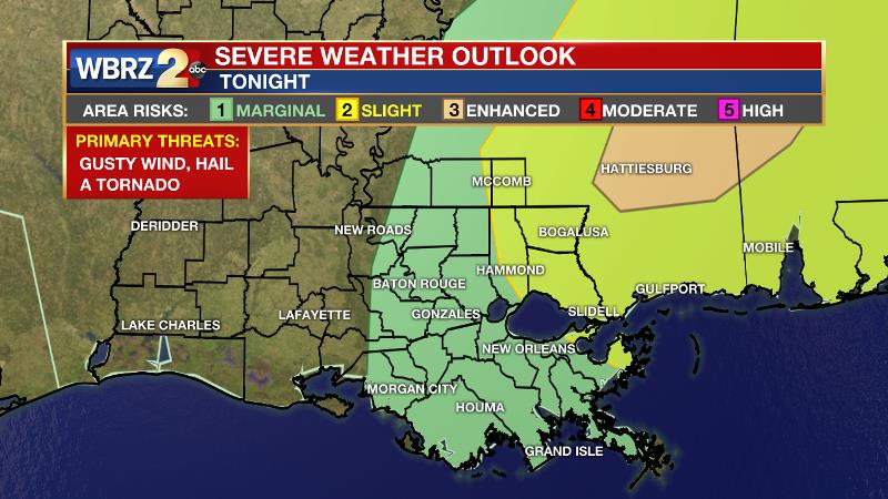
Ahead of the next cold front, showers and thunderstorms are possible overnight and one or two storms could even turn strong. However, widespread severe weather and heavy rain are not expected.
THE FORECAST:
Today and Tonight: Tuesday will be sunny and warm with high temperatures in the middle 80s. Clouds and humidity will return overnight as a warm front lifts through the region. The NWS SPC has placed areas east of I-55 under a “slight risk” for severe storms. There, showers and thunderstorms are expected tonight and there will be a brief window of opportunity for those storms to strengthen before a cold front arrives on Wednesday Morning. West of I-55, showers and thunderstorms should be weaker and isolated with some locations receiving no rain at all. Low temperatures won’t drop out of the upper 60s.
Up Next: Any showers and thunderstorms will end by noon Wednesday with sunshine returning for the afternoon. Perhaps even better news, a nice cool down and very pleasant stretch of weather will ensue. Thursday through Saturday will bring clear skies with lows near 50 and highs near 75. By Sunday, while still dry, temperatures will once again climb above 80 degrees. The next reasonable chance at rain will come early next week.
Trending News
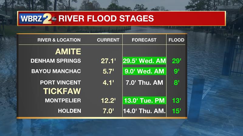
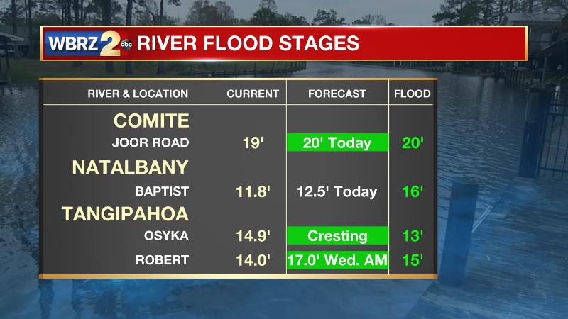
Some nuisance flooding continues along area rivers. Fortunately, there will be plenty of time before the next sizeable rain, giving water time to recede. See below for the latest river level and expected crests.
THE SCIENCE: The cold front that moved through yesterday is stalled over the Gulf of Mexico this morning and will slide back to the north as a warm front later today. Conditions supportive of showers and thunderstorms will begin to move into the picture early Wednesday in the form of a cold front with plenty of dynamic and thermal support. The timing of this front is the question. Since it will supply what is necessary for severe thunderstorms, the area where it comes into contact with deep moisture, instability and lift will be the area in focus tonight and Wednesday. The warm front will begin to move north today. Strong to severe thunderstorms will once again be possible as it moves onshore this evening. Storms will not be widespread and should mainly be found east of I-55 and any severe storms should be over southeast Mississippi and adjacent parishes of the northshore. Activity should move into the area from the south by tonight and linger until a cold front moves through tomorrow morning. NWS SPC has hashed out a tight area with “slight” and “enhanced” risk for severe weather. In those areas, all modes of severe weather are possible. Then, a cold front will quickly end any threats from west to east through the morning hours with sunshine by afternoon. Winds behind this front look to be a little stronger and will bring in cooler and drier air. After that, a surface high pressure system will move from Colorado to Florida between Thursday and Sunday. With light northerly wind sin place through Friday, low temperatures will be a few degrees below average with some lows pushing the upper 40s. By Sunday, as that high sets up in Florida, southerly winds will return and temperatures will moderate above average.
--Josh
More News
