

Latest Weather Blog
Friday PM Weather: EXCESSIVE HEAT WARNING continues into weekend
The National Weather Service has issued an EXCESSIVE HEAT WARNING and HEAT ADVISORY for Saturday from 9am – 7pm across southeast Louisiana and southwest Mississippi. For locations under An EXCESSIVE HEAT WARNING, the heat index, or feels-like temperature, could exceed 113 degrees. For locations under a HEAT ADVISORY, the heat index, or feels-like temperature, could be between 108 and 113 degrees. CLICK HERE for the detailed forecast from your WBRZ Weather Team.
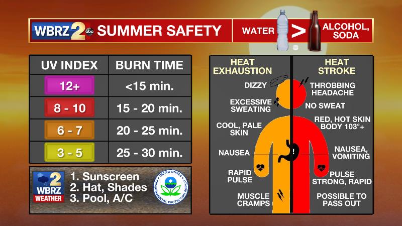
This extreme heat and humidity will significantly increase the potential for heat related illnesses, particularly for those working or participating in outdoor activities. Drink plenty of fluids, stay in an air-conditioned room, stay out of the sun, and check up on relatives and neighbors. Young children and pets should never be left unattended in vehicles under any circumstances.
Take extra precautions if you work or spend time outside. When possible reschedule strenuous activities to early morning or evening. Know the signs and symptoms of heat exhaustion and heat stroke. Wear lightweight and loose fitting clothing when possible. To reduce risk during outdoor work, the Occupational Safety and Health Administration recommends scheduling frequent rest breaks in shaded or air conditioned environments. Anyone overcome by heat should be moved to a cool and shaded location. Heat stroke is an emergency! Call 9-1-1.
Next 24 Hours: The remnants over any showers will decay by midnight. Even giving way to a mostly clear sky, lows will not drop much lower than 76 degrees. The very hot temperatures will continue on Saturday with mostly sunny skies sending highs into the mid 90s and feels-like temperatures closer to 110 degrees. Isolated showers or thunderstorms are possible during the mid to late afternoon hours, especially south and east of Baton Rouge.
Trending News
Up Next: Air temperatures will surge back into the middle 90s on Sunday. With dew point temperatures staying in the middle 70s, feels-like temperatures will be well into the low 100s. These unpleasant to dangerous conditions will last from mid-morning through mid-afternoon before any organized showers and thunderstorms and develop. Rain coverage within the 13 Parish, 3 County Forecast Area will be between 20 and 40 percent. A weak front is expected to move into the area early next week resulting in scattered to widespread showers and thunderstorms. Greater coverage and earlier development will lead to slightly cooler temperatures--especially Monday and Tuesday. There are some signs that this front could move far enough south to reduce humidity a bit by the end of next week. CLICK HERE for your full 7-Day Forecast.
The Tropics: For the North Atlantic...Caribbean Sea and the Gulf of Mexico, tropical cyclone formation is not expected during the next 5 days. For the latest tropical forecasts and information, visit the WBRZ Hurricane Center as we navigate all 183 Days of Hurricane Season.
Get hour-by-hour weather and right now weather conditions for your location on the WBRZ WX App on your Apple or Android device. Follow WBRZ Weather on Facebook and Twitter for even more weather updates and unique weather insight from the whole team!
More News
