

Latest Weather Blog
Friday PM Forecast: A sunny weekend but the rain is coming
Outdoor events are in great shape this weekend. After a chilly start to Saturday, it will be back to shorts and short sleeves on a warm finish to Sunday.
Next 24 Hours: The coolest part of the extended forecast will come tonight. Low temperatures will be in the low 40s, but if winds lighten more than expected, a few typically cooler spots could sneak into the upper 30s. Ample sunshine will stick around through Saturday afternoon. High temperatures will rebound into the mid 70s with northwest breezes of 5-10mph.
Up Next: Expect more sunshine and warmer temperatures on Sunday with highs getting back into the low 80s. Some clouds may start to develop late in the weekend and will certainly increase on Monday as moisture and humidity return. Starting Monday afternoon, several rounds of mainly afternoon showers and thunderstorms will be possible until a cold front sweeps through the area early Thursday. At this time, it appears as though the most favorable ingredients for severe weather will remain north of the area, but it is too early to call anything definitively. The area could receive a beneficial 1-3 inches of rain through next week—especially north and west of the city. CLICK HERE for your detailed 7-Day Forecast.
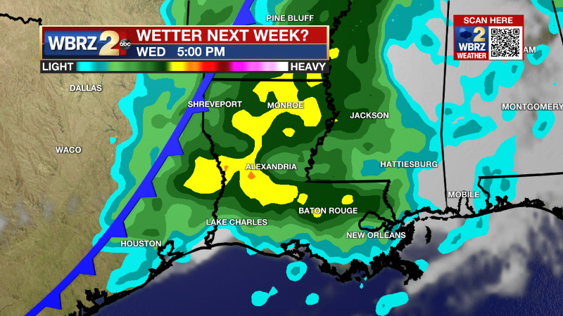
The Explanation: The coldest night of the extended forecast is ahead with low temperatures in the low 40s and possibly upper 30s. At this time, frost is not expected as winds will remain in the 5-10mph range. If they slacken more, lower than expected temperatures could result in a few patches in southwest Mississippi. By Sunday, the influence of an upper level trough will begin to wane as it moves to the east and a deep ridge of high pressure will take hold over the Gulf South. As a result, sinking air will keep skies clear and humidity low as high temperatures warm back into the 80s. Increasing onshore flow will bring higher dew point temperatures and low temperatures back into the 60s overnight into Monday. As the upper level ridge budges farther east on Monday and Tuesday, a persistent and deep southwest flow will develop in the upper levels of the atmosphere. A series of weak, but fast moving disturbances will move through the area as moisture continues to increase from the surface into the low levels. Warming temperatures will result in some instability, especially in the afternoons near maximum temperatures, and isolated to scattered showers and thunderstorms should be able to develop each day through the middle of next week. Overall, greater coverage is expected north and west with lesser activity south and east. A stronger upper level trough of low pressure and associated cold front will press through the area Wednesday night into Thursday. While wind shear may become slightly more favorable for stronger thunderstorms, the most favorable ingredients for severe weather are pegged to be north of the area at this time. The cold front will sweep through with a band of showers and thunderstorms on Thursday morning followed by slightly cooler and drier air.
--Josh
Trending News
The Storm Station is here for you, on every platform. Your weather updates can be found on News 2, wbrz.com, and the WBRZ WX App on your Apple or Android device. Follow WBRZ Weather on Facebook and Twitter for even more weather updates while you are on the go.
More News
