

Latest Weather Blog
After historic rain and flood event, more showers and storms possible
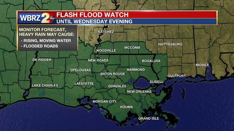
A FLASH FLOOD WATCH is posted for the entire viewing area, through Wednesday evening. Additional rainfall of 1 to 3 inches with locally higher amounts will be possible. The most likely areas for heavy rainfall will be along and south of the I-10/12 corridor in Southeast Louisiana including portions of metro Baton Rouge and metro New Orleans. These heavier rainfall amounts could cause localized flash flooding issues. High rainfall rates could overwhelm drainage capacity. Ponding of water in low lying and poorly drained areas will be possible, and flash flooding could occur where the heaviest rain occurs.
Tonight and Tomorrow: Tuesday night will not be a repeat of Monday night. Scattered showers and thunderstorms will continue to drop in coverage and intensity into the evening. Overnight is expected to be largely quiet with low temperatures in the upper 60s. It will remain breezy with easterly winds of 10-15mph. The next batch of rain and storms will approach from the west early Wednesday. Perhaps in a somewhat organized line, thunderstorms will again be capable of gusty wind and torrential rain. Scattered showers and thunderstorms will remain possible through the day. Mostly cloudy skies should keep high temperatures in the upper 70s and low 80s.
Up Next: The threat for showers and thunderstorms will continue on Thursday, particularly during the afternoon hours. Daytime warming should be the key trigger in initiating activity. Some briefly heavy or gusty storms will remain possible. As far as temperatures go, highs will be in the low 80s with lows in the low 70s. Friday will bring a transition with slightly warmer and drier conditions, though a pop-up, afternoon shower or storm will remain possible. Over the weekend, a drier pattern will take hold with sunny and warm afternoons, pushing 90 degrees. Humidity will not quite be to summertime levels, allowing overnight readings in the mid 60s. CLICK HERE for your full 7-Day Forecast.
Trending News
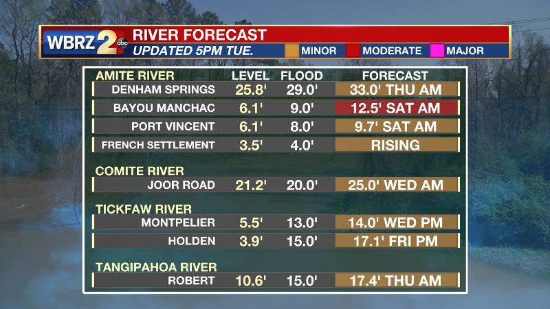
Runoff from heavy rain may have you concerned about area rivers. While they will rise in response to the rain, since the highest amounts occurred south of the larger basins, most flooding will be minor and similar to what has already been experienced this year. The Amite River and Bayou Manchac, beneath the bulls-eye of the heaviest rain so far, will be a little bit more significant reaching moderate flood stage. At 9 feet, the river will begin to flood property along Bayou Manchac and the Amite River. At 12 feet, Kendalwood Road and adjacent property will be inundated. Backwater may flood Bayou Fountain and flood some homes on Burbank Drive. Most secondary roads will be moderately flooded. Amite River Road and Horseshoe Drive will be impassable. A few homes on Horseshoe Drive will flood.
--Josh
The WBRZ Weather Team is here for you, on every platform. Your weather updates can be found on News 2, wbrz.com, and the WBRZ WX App on your Apple or Android device. Follow WBRZ Weather on Facebook and Twitter for even more weather updates while you are on the go.
More News
