

Latest Weather Blog
Thursday evening video forecast
Related Story
If you spent any time outside on Thursday, you probably sensed the return of the humidity. Coupled with temperatures in the 90s, feels-like temperatures pushed 100°. The addition of humidity is priming the atmosphere for storm development. It looks like many of us will have to dodge storms over the weekend as the summer-like feel continues.
Tonight & Tomorrow: A few clouds will linger on Thursday night, resulting in partly cloudy skies across the area. Overnight lows are also continuing to warm. We’re forecasting an overnight low in the lower-70s in the metro area. This is a contrast to the many mornings we’ve had with lows in the 60s this week.
Friday will feature partly sunny skies. It’ll be warm and muggy, with a high temperature in the low to mid-90s. A minor disturbance will also be swinging through. This time, we should have enough moisture to see spotty storm development on Friday afternoon. We’re looking at a 20% rain coverage. Although a lingering shower will be possible on Friday evening, the overall activity should diminish.
Up Next: The humidity continues to hold on for the weekend. Both Saturday and Sunday will feature partly sunny skies with temperatures rising into the lower and middle-90s. We are also including a spotty storm chance each day. Storms that do form would develop in the heat of the day and be hit-or-miss in nature. The weekend will not be a washout by any means.
We’re bumping up rain chances into Monday and Tuesday as the longer-term data signals the arrival of a cold front. The hope is that we can get some meaningful rain out of it.
Get the latest 7-day forecast and real time weather updates HERE.
Watch live news HERE.
Tropics: Hurricane Nigel continues to drift northeast toward cooler waters in the Atlantic basin. Nigel is still no threat to land and is forecast to become post-tropical on Thursday night or Friday morning.
Meanwhile, the National Hurricane Center is issuing products for Potential Tropical Cyclone (P.T.C) Sixteen. The system has “potential” affixed to its name because it is not yet a tropical system, but it may become one and affect land within 48 hours. P.T.C. Sixteen is positioned east of the Florida Peninsula and will move north into the weekend.
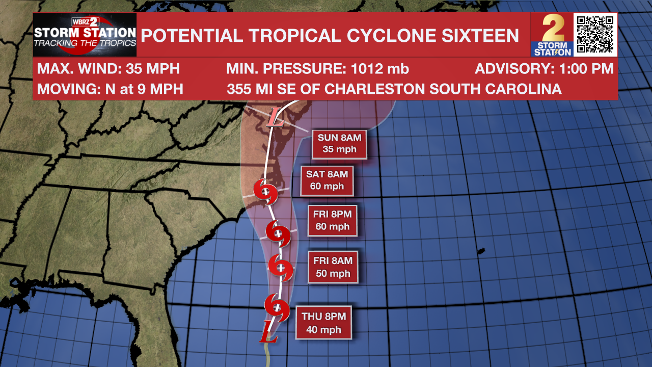
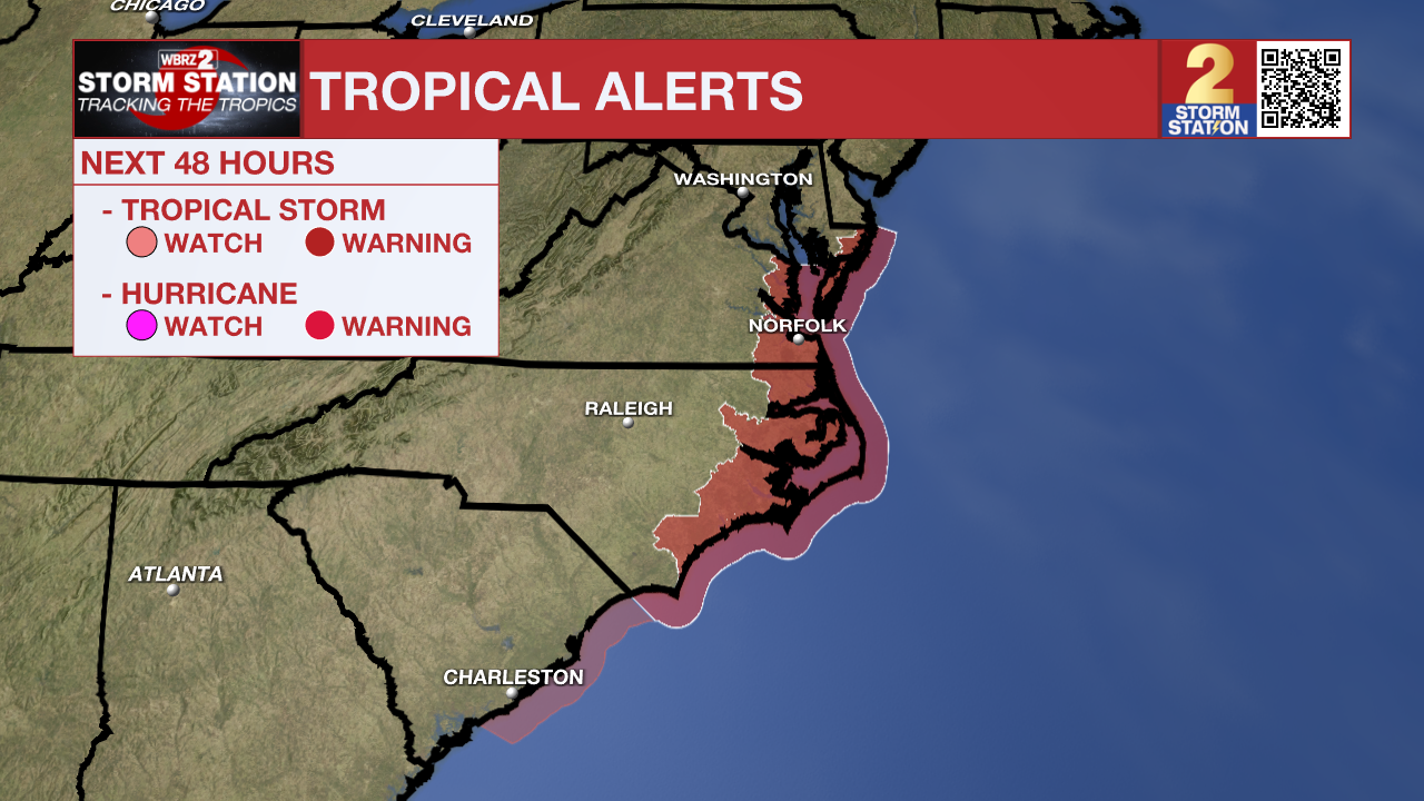
A landfall along the North Carolina coast looks possible early Saturday. Tropical Storm Watches and Warnings are in effect across the Southeast coast, extending north into Chesapeake Bay.
There is a chance that the system will not acquire tropical characteristics. Should that happen, the storm will not be given a name or number. Regardless, gusty winds, heavy rain, and storm surge to the region. The storm will not pose any threat to Louisiana.
In addition, there is another broad area of low pressure a couple hundred miles southwest of the Cabo Verde Islands that is showing signs of organization. Conditions are forecast to be conducive for gradual development of the system, and a tropical depression is likely to form this weekend or early next week while the system moves west toward the central Atlantic.
-- Meteorologist Malcolm Byron
The Storm Station is here for you, on every platform. Your weather updates can be found on News 2, wbrz.com, and the WBRZ WX App on your Apple or Android device. Follow WBRZ Weather on Facebook and Twitter for even more weather updates while you are on the go.
News
