

Latest Weather Blog
Monday PM Forecast: Heat set to intensify toward the weekend; tracking the tropics
Afternoon storm chances will fade in the coming days, allowing heat to tighten its grip on the Capital Region. Meanwhile, the Storm Station is tracking several areas of interest across the Atlantic.
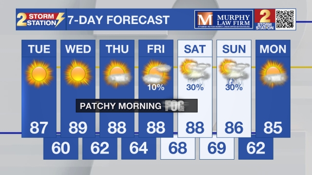
Tonight & Tomorrow: Following the classic summer setup, afternoon thunderstorms will diminish into the night. Skies will clear overnight, and morning lows will settle in the mid-70s. Temperatures will find the mid-90s on Tuesday afternoon, though it will feel roughly 10° warmer thanks to humidity. Approximately 30% of the area will come across an isolated thunderstorm in the heat of the day. While many will stay dry, these storms could produce a quick burst of heavy rain, frequent lightning, and gusty winds. Expect rain to fizzle fast during the evening.

Up Next: The number of afternoon thunderstorms will decrease with each passing day through the rest of the week due to a ridge of high pressure. The warm, sinking air associated with it will suppress storm development. As it takes root over the region over the weekend, expect high temperatures to soar. Upper 90s will be a possibility starting this weekend. High humidity, combined with the intense heat, could trigger heat alerts over the weekend and especially into next week.
The Tropics: As August continues and the peak of hurricane season approaches, the Atlantic is beginning to stir. The most notable system to watch is an area of low pressure located a few hundred miles southwest of the Cabo Verde Islands. A tropical wave emerging off the coast of West Africa will interact with it in a few days. Environmental conditions will be more favorable for development by midweek, and a tropical depression could form during the latter half of the week. There is a 70% chance of development over the next week. At this time, there is no threat to the Gulf Coast.

Trending News
Two other waves have a 10% chance of development, but neither will threaten the Gulf Coast. The first, located halfway between West Africa and the Lesser Antilles, has only a brief window to organize before conditions become more hostile. The second, north of Bermuda, faces a similarly brief window before moving over cooler waters late this week.
Get the latest 7-day forecast and real-time weather updates HERE.
Watch live news HERE.
— Meteorologist Malcolm Byron
The Storm Station is here for you, on every platform. Your weather updates can be found on News 2, wbrz.com, and the WBRZ WX App on your Apple or Android device. Follow WBRZ Weather on Facebook and X for even more weather updates while you are on the go.
More News

