

Latest Weather Blog
Monday AM forecast: Heat builds this week as rain chances fade
The heat will become the bigger weather story across the Capital Region this week as temperatures climb and afternoon storms become harder to find. Storms are still possible Monday, but by the middle and latter part of the week, much of the area could stay dry as a building ridge shuts down most of our rain chances.

Today and Tonight: Monday starts as another hot and humid day, but there will still be enough Gulf moisture around for isolated to scattered showers and thunderstorms during the afternoon. Any storm that does develop will be slow-moving and could produce a quick burst of heavy rain, frequent lightning and some gusty winds.

Use the slider to advance through the next 24 hours of Futurecast
Temperatures will climb into the low to mid 90s, with heat index values generally between 105 and 108 degrees in the hottest spots, especially where storms don't develop until later in the afternoon.
Trending News
Up Next: The big change comes Tuesday through the rest of the week as high pressure strengthens overhead. That will make it increasingly difficult for showers and thunderstorms to develop, with only an isolated storm or two possible Tuesday and Wednesday. By Thursday and Friday, rain chances could become very low, and some areas may go several days without measurable rain. That means more sunshine and longer stretches of dangerous heat.
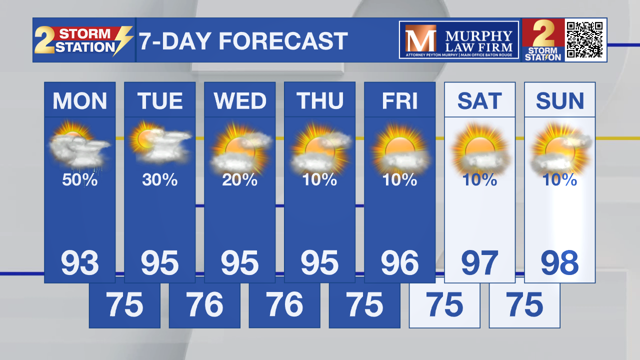
Afternoon highs will remain in the mid 90s, while heat index values become the bigger concern. Readings of 105 to 110 degrees will become more common, and Heat Advisories will likely be needed at times later this week. The heat may continue into the upcoming weekend, with very little relief expected unless a stray storm develops. Some locations could make a run at 100 degrees, especially farther west and north of the Capital Region.

Tropics: The Atlantic is becoming more active, with the National Hurricane Center now monitoring three areas. The most notable is a small area of low pressure south of the Cabo Verde Islands that has a 60% chance of development over the next seven days; another wave farther west has only a 10% chance. At this time, there are no threats to the Gulf.
Get the latest 7-day forecast and real-time weather updates HERE.
Watch live news HERE.
– Dave
The Storm Station is here for you, on every platform. Your weather updates can be found on News 2, wbrz.com, and the WBRZ WX App on your Apple or Android device. Follow WBRZ Weather on Facebook and X for even more weather updates while you are on the go.
More News

