

Latest Weather Blog
Air Quality Alert for Wednesday, Tropical moisture to move in Friday
Air Quality Alert issued for the Baton Rouge and New Orleans Metro areas.
An *AIR QUALITY ALERT* has been issued for the Baton Rouge area for Wednesday. Light winds will reduce pollutant dispersion and continued warm temperatures and sunny skies will enhance ozone formation. Therefore, air quality levels will be Unhealthy for Sensitive Groups in the Baton Rouge area. You can help mitigate this issue and reduce emissions by driving less and refueling very early or very late in the day.
THE FORECAST
Today & Tonight: Today, besides the Air Quality Alert, conditions are very calm. Temperatures will be steamy in the mid-90s with the heat index near 100 degrees. A stray shower is always a possibility, but rain chances today will be very low. Overnight temperatures will be in the 70s.
Up Next: Temperatures will be in the 90s with heat index values near 100 degrees in the peak of the afternoon on Thursday. Overnight temperatures will be in the mid-70s. Looking ahead to Friday, tropical moisture is set to move in. The forecast is largely dependent on the disturbance in the Gulf, so there is still a lot of uncertainty. Tropical showers will be in the area as early as Friday morning. Saturday and Sunday will likely be washouts with temperatures in the 80s. Altogether, rainfall totals will likely be 5-7 inches with isolated higher amounts. Continue to check back for daily updates. Scroll down for more on the tropics. Click here to see the 7-day forecast.
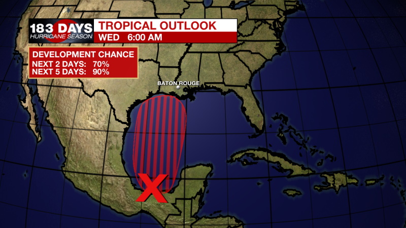
In the Tropics:
Wednesday 7am Tropical Outlook
Trending News
Confidence in the forecast for this system continues to increase. Development into a tropical depression could happen as early as this evening but will likely happen on Thursday. It is then forecast to move north and bring deep tropical moisture to the Gulf Coast. It won’t have much time to become perfectly organized before reaching the Gulf Coast. This means it will likely be lopsided with the east side of the storm seeing most of the rain. Gusty winds will come along with tropical showers and storms. Click here to visit the WBRZ Hurricane Center.
Reminder: With the threat for impactful weather—tropical thunderstorms—please have access to alerts through Saturday. You can download or activate the WBRZ WX App on your Apple or Android device or turn on a NOAA Weather Radio for bulletins such as watches and urgent warnings. Of course, WBRZ, WBRZ+ and the Cable Weather Channel will have updates as active weather dictates.
More News
