

Latest Weather Blog
Monday morning video forecast
Related Story
All eyes are already on the weekend forecast… we are cold front tracking this week!
THE FORECAST
Today & Tonight: A weak boundary may push through a few showers this morning, and then a few pop-up showers will be possible again this afternoon. Overall, skies will be mostly sunny, about 20% of the area is expected to see rain today. Temperatures will max out near 88 degrees and with a bit of humidity, you can add on a few more degrees for a heat index. Overnight lows will be muggy too, near 70 degrees.
Up Next: The summery pattern of muggies and a few showers will continue through this week. Since the humidity will be high through Friday, there will be enough moisture for a stray shower or two each afternoon. We are not tracking any washouts. Temperatures will trend in the upper 80s and overnight lows will be near 70 degrees. As we approach the weekend, a cold front will bring increased rain coverage on Friday and Saturday. Behind this front, some cooler and drier air will settle in. High temperatures will be capped in the 70s starting on Saturday and overnight lows will dip into the 50s. Click here to see the 7-day forecast.
In the Tropics:
None of the tropical activity is currently a threat to the local area.
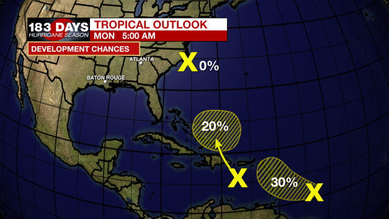
A non-tropical low-pressure area located just off the North Carolina coast continues to produce some disorganized showers and thunderstorms. Although this system is not expected to become a tropical or subtropical cyclone, locally heavy rainfall and gusty winds are still possible over portions of the North Carolina Outer Banks today and information on these hazards can be found in products issued by your local National Weather Service Office. Additional information on this low-pressure system, including gale warnings, can be found in High Seas Forecasts issued by the National Weather Service. Formation chances through the next 5 days is very low, 0%.
A tropical wave located about 400 miles east-southeast of the Windward Islands continues to produce disorganized cloudiness and thunderstorms. Some slow development is possible during the next day or two while the system moves west-northwestward at about 15 mph toward the Lesser Antilles. After that time, strong upper-level winds are expected to limit further development. Regardless of development, the system could produce locally heavy rainfall and gusty winds across portions of the central and northern Lesser Antilles on Tuesday, and across the Virgin Islands and Leeward Islands on Wednesday. Formation chances through the next 5 days is low, 20%.
Another tropical wave located over the eastern Caribbean Sea is producing a large area of disorganized cloudiness and showers. Unfavorable upper-level winds are expected to limit development over the next day or so, but environmental conditions could become a little more conducive for some gradual development of the system when it is located near the southeastern Bahamas around midweek. Regardless of development, locally heavy rainfall is possible over portions of the Lesser Antilles, Puerto Rico, and Hispaniola during the next couple of days. Formation chances through the next 5 days is very low, 10%.
The WBRZ Weather Team is watching the tropics around the clock and will bring you updates as they come. Click here to visit the Hurricane Center.
Need weather conditions HOUR BY HOUR? Get hour by hour weather and right now weather conditions for your location on the WBRZ WX App on your Apple or Android device. Follow WBRZ Weather on Facebook and Twitter for even more weather updates and unique weather insight from the whole team!
News
