

Latest Weather Blog
Friday morning video forecast
Related Story
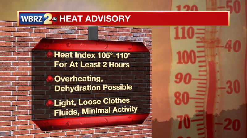
A HEAT ADVISORY has been issued for parts of the WBRZ viewing area.
*HEAT ADVISORY* for the shaded area. Keep an eye on kids, pets, the elderly and check the backseat! #lawx #mswx pic.twitter.com/WPcPjjnL1h
— WBRZ Weather (@WBRZweather) July 22, 2021
THE FORECAST
Today & Tonight: The Baton Rouge area is under a heat advisory from 9am this morning through 7pm tonight. Temperatures will be between 92-95 degrees over the area, with that the heat index values will climb between 105-108 degrees in the peak of the afternoon. Be sure to drink plenty of water and take breaks from the sun. There may be a stray shower near the coast this afternoon, but don’t count on any rain to cool things off. Overnight temperatures will be in the mid-70s.
Sun and Heat Safety: Some friendly reminders for your summer of fun events—sunburn can occur in less than 15 minutes with the extreme U.V. Index typical of this time of year. In addition to that, heat exhaustion and heat stroke can set in just as quickly. Seek medical attention if you or somebody you know is affected. While we all enjoy a list of cool beverages, be sure water is at least a part of that list! Finally, look before you lock. DO NOT leave people or pets in an unattended car.
Up Next: There will be long periods of dry time on Saturday and Sunday while isolated showers move in and out. Temperatures will trend near 92 degrees with a heat index near 100 degrees. It is possible that the heat advisory is extended through parts of the weekend. Scattered showers are expected on Saturday, but they will come later in the day, between 6-9pm. Saturday evening plans may run into a few showers particularly for areas east of Baton Rouge. Showers on Sunday will bubble up in the afternoon and may offer some brief relief from the heat.
Although rain is in the forecast every day, not every area will see rain each day. Continue to check back in with the Weather Team each day for more details on the daily rain coverage. Click here to see the 7-day forecast.
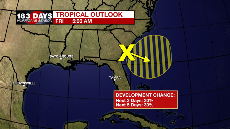
In the Tropics:
The low pressure that has acted as a rainmaker for South Louisiana earlier in the week is set to move across the southeast and emerge into the Atlantic over the weekend. Once the system is over open water, it has a 30% chance of developing into a tropical depression. The local area has actually already seen the impact from this low pressure center and any further development is not forecast to impact the local area again. Click here to visit the WBRZ Hurricane Center.
Need weather conditions HOUR BY HOUR? Get hour by hour weather and right now weather conditions for your location on the WBRZ WX App on your Apple or Android device. Follow WBRZ Weather on Facebook and Twitter for even more weather updates and unique weather insight from the whole team!
News
