

Latest Weather Blog
Thursday PM Forecast: dry stretch continues, good for football games but bad for the drought
Sunny skies and dry conditions will dominate the Capital Area over the coming days, keeping high temperatures in the lower-to-mid 80s while morning lows dip into the 50s. However, worsening drought conditions and rising weekend winds will significantly elevate the chances for fires to spark, so burn with caution or avoid entirely where bans are in place.

No Rain: drought conditions will worsen over the next week
Fire Danger: low humidity and warm conditions will allow fires to spark easily
Next Cold Front: a weak one next week, likely without any rain or major changes
Trending News
Tonight & Tomorrow: Clear skies and comfortable conditions will repeat across the Baton Rouge Area tonight. Temperatures will fall into the low 50s for communities north of Interstate 10, while areas south will see morning lows in the mid-50s. Friday will deliver another warm, brilliant October afternoon with abundant sunshine. Temperatures will peak in the mid-80s with light northeast winds around 5 to 10 mph. For the Friday Night Blitz, expect clear skies and light winds with temperatures falling through the 70s and into the 60s during the games. It might be a good idea to bring some layers to add.
Up Next: The overall atmospheric pattern is currently locked in a pattern with high pressure overhead that deflects storm systems around the region while keeping unseasonably warm, dry air in place. As a low-pressure system moves across the Caribbean over the weekend, it will tighten the pressure difference over Louisiana, cranking up local wind speeds. You will notice the breezes pick up Saturday and Sunday, with inland gusts reaching up to 20 mph. Combined with our worsening drought, these winds will elevate fire weather concerns even further across the region. There will also be some cooler air moving into the atmosphere that reduces high temperatures a few degrees into the low 80s.
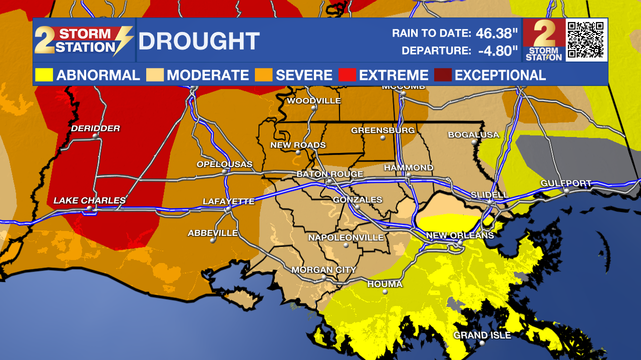
The stubborn pattern will give a little early next week, allowing a weak cold front to move through on Tuesday. Unfortunately for local lawns and gardens, this will be a dry passage with rain chances below 10%. The front will simply reinforce the dry, continental air mass, keeping high temperatures in the low 80s and nighttime lows near 50 degrees through midweek.
Get the latest 7-day forecast and real-time weather updates HERE.
Watch live news HERE.

The Tropics: The Gulf and Caribbean remain completely quiet with no tropical threats to Louisiana or Mississippi. Out in the open Atlantic, Subtropical Storm Josephine is moving northeastward roughly 200 miles southeast of Nantucket, Massachusetts, with maximum sustained winds of 65 mph. Josephine is accelerating out to sea and transitioning into a powerful non-tropical system over the cold waters of the North Atlantic. The storm continues to drive strong surf and hazardous rip currents along portions of the U.S. East Coast. Elsewhere, a weak area of low pressure east of Bermuda has a minimal 10% chance of development before upper-level winds shut it down this weekend.
– Josh
The Storm Station is here for you, on every platform. Your weather updates can be found on News 2, wbrz.com, and the WBRZ WX App on your Apple or Android device. Follow WBRZ Weather on Facebook and X for even more weather updates while you are on the go.
More News

