

Latest Weather Blog
THE LATEST: Marco impacts coast, Watching Laura closely
Environmental factors have significantly diminished Tropical Storm Marco. Outer rainbands are struggling to hold together and all the watches and warnings have been removed from the Baton Rouge Metro area. The largest impacts will be isolated to the coast in the form of storm surge and strong winds. Isolated showers could be strong over the Baton Rouge area today, and the main threat is the possibility of isolated tornados. There will be periods of sunshine today between showers and storms.
?? #BatonRouge: Marco is a DUD, not a bad day at all ??, relatively speaking. Important to note that we could still have some gusty showers and coastal areas could still have wind and surge but apart from that, impacts will be minor. pic.twitter.com/Ae4H2ueCuW
— Josh Eachus (@DrJoshWX) August 24, 2020
A TROPICAL STORM WARNING Has been issued for Assumption, St. James, and St. Mary parishes.
A STORM SURGE WARNING has been issued from Sabine Pass eastward to the Alabama/Florida border, including Lake Pontchartrain, Lake Maurepas, Lake Borgne, and Mobile Bay. 3 - 5 feet of water is expected in Lake Maurepas, Lake Pontchartrain and in the Grand Isle area west through St. Mary Parish.
A FLASH FLOOD WATCH has been issued for Assumption, St.James Parish, and St. Mary parishes from 1 am Monday through 3 am Tuesday morning.
Trending News
METRO BATON ROUGE IMPACTS:
- Intermittent rain, some heavy, with the potential for 1" to 3" - higher totals east and along the immediate coast.
- Gusty winds: Sustained 15 - 25 mph, 40 mph gusts possible.
- Spin up tornadoes can't be entirely ruled out, especially east of Baton Rouge.
BEST ESTIMATED TIMELINE:
- Early Morning: Rain bands moving in.
- Afternoon - Evening: Periods of heavy rain, occasional gusty winds.
- Overnight: Rain lessens, breezy at times.
Watch live, late-breaking updates and all WBRZ newscasts online here
LAURA: Click here for the forecast cone.
As of 10 AM Monday, with 65mph winds, Tropical Storm Laura was 65 east-southeast of Cayo Largo, Cuba moving west-northwest at 20 mph. As Laura continues west-northwest over the next few days it will interact with Cuba, perhaps limiting significant strengthening. However, Laura will emerge in the eastern Gulf of Mexico to highly favorable conditions for strengthening early next week. While the forecast of the system has also undergone a number of changes over the last few days, Laura is currently expected to make landfall near Vermilion Bay, Louisiana as a category 2 hurricane. Any rain, wind and surge impacts could be amplified simply due to the short time between Laura and Marco.
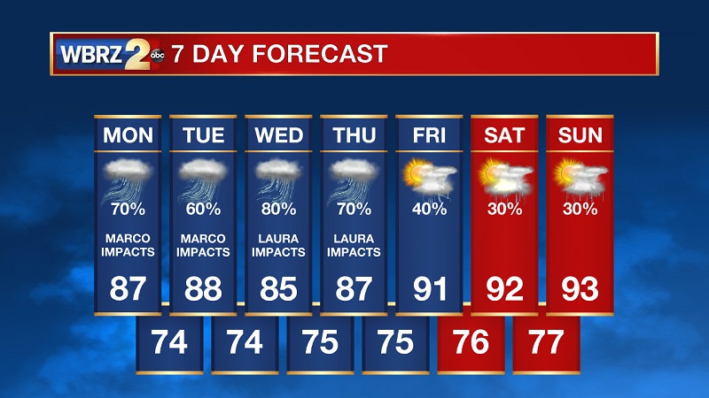
Up Next: Tuesday may continue to bring some tropical showers to the area, but serve as a lull in active weather as we await the ultimate track of Laura. At this time it appears as though Laura could begin spreading some rain northward into the region as early as Wednesday morning. With the current forecast track, the Baton Rouge area could experience heavy rain, strong winds and isolated tornadoes Wednesday and Thursday. Surge could still be a significant problem on the coast. The pattern should finally ease toward normal as we move into next weekend.
The WBRZ Weather Team is here for you, on every platform. Your weather updates can be found on News 2, wbrz.com, and the WBRZ WX App on your Apple or Android device. Follow WBRZ Weather on Facebook and Twitter for even more weather updates while you are on the go.
More News
