

Latest Weather Blog
Monday AM Forecast: Flash Flood Watch issued for WBRZ viewing area
A Flash Flood Watch is out until 9pm for all the the WBRZ viewing area.
THE FORECAST
Today & Tonight: The weather story today is widespread showers and storms. There is deep tropical moisture over our area, some shower activity will be around in the morning for areas north of Baton Rouge. This afternoon showers and storms will be more widespread as they push south. There is a Flash Flood Watch issued for all areas except for St.Mary Parish, but heavy downpours are still possible there. Storms today will be capable of dropping 2-3 inches of rain in a short period of time. Under normal circumstances this would be manageable, but many areas are not in a position to take on heavy downpours. Have a way to receive warning information in the event of a flood warning for your area.
***FLASH FLOOD WATCH*** for the shaded area. We'll have updated forecasts and post warnings, if issued. #lawx #mswx pic.twitter.com/KsTEHFD7By
— WBRZ Weather (@WBRZweather) September 6, 2021
All the rain will keep temperatures from heating up too much. Afternoon highs will max out in the upper 80s in the dry spots. Rain will drop the heat index into the 80s or even the 70s. Overnight lows will drop into the mid 70s.
Trending News
Up Next: Some deeper tropical moisture will stay over the area through Wednesday. This is going to cause widespread showers and storms on Tuesday afternoon as well. The rain will prevent temperatures from climbing too high. Temperatures will max out in the upper 80s and overnight lows will be in the low 70s. Starting Wednesday, some drier air will work in from the north and rain coverage will be much more isolated. Temperatures will be in the upper 80s through the rest of the week. The drier air will drop overnight lows into the 60s starting on Thursday night. There are no rain chances Thursday through the weekend. Click here to see the 7-day forecast.
In the Tropics:
A disturbance over the Yucatan is expected to increase rain coverage on the Gulf Coast for the first half of the week. No development expected in the Gulf of Mexico.
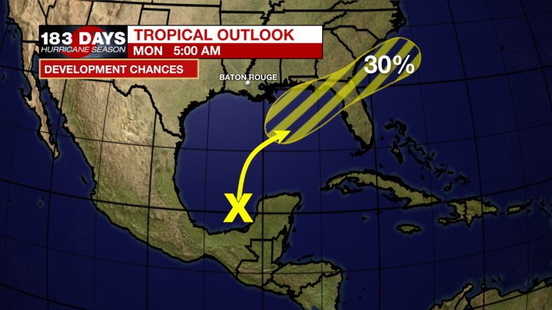
Disorganized showers and thunderstorms over the Yucatan Peninsula and surrounding waters are associated with a surface trough and an upper-level disturbance located over the eastern Bay of Campeche. Locally heavy rains are likely to continue through tonight over that area. The system is forecast to move slowly northward or northeastward over the central and then northeastern Gulf of Mexico over the next few days. Although upper-level winds are currently unfavorable for development to occur, they are expected to become marginally conducive for tropical cyclone formation by late Tuesday. The disturbance is then expected to cross the southeastern United States beginning midweek, and some development will be possible once it emerges over the Atlantic waters by late this week.
The WBRZ Weather Team is watching the tropics around the clock and will bring you updates as they come. Click here to visit the Hurricane Center.
Need weather conditions HOUR BY HOUR? Get hour by hour weather and right now weather conditions for your location on the WBRZ WX App on your Apple or Android device. Follow WBRZ Weather on Facebook and Twitter for even more weather updates and unique weather insight from the whole team!
More News
