

Latest Weather Blog
Monday morning video forecast
Related Story
A cold front passed through south Louisiana late Sunday. This brought a slightly drier air mass into the area, which will hang on early in the week.
THE FORECAST:
Today and Tonight:
Early clouds will depart for plenty of sunshine in the afternoon. Expect highs to top out around 80 degrees. Clear skies will continue overnight with lows around 65 degrees.
Up Next: Humidity will quickly return as we move toward mid-week. Rain chances will also return to the forecast. Wednesday through Saturday, we could see the traditional pop-up afternoon showers or thunderstorms, which of course is common this time of the year. Temperatures will steadily warm through the week as well with high temperatures getting close to 90 by Thursday.
It has been a while since we talked about those rain chances, or percentages on the forecast board often seen during the warm season. Here is a quick reminder about what those mean for the WBRZ Weather 13 Parish, 3 County forecast area.
10-30% - Isolated: a few locations receive measurable rain
30-60% - Scattered: part to half of the area receives measurable rain
60-100% - Widespread: almost all of the area receives measurable rain
Keep in mind, those chances tell nothing about timing. For instance, 100% DOES NOT mean it will rain all day. We will be sure to provide information in our forecasts as to when you can expect rain when chances are on the board. MORE: https://www.wbrz.com/news/a-chance-to-remember
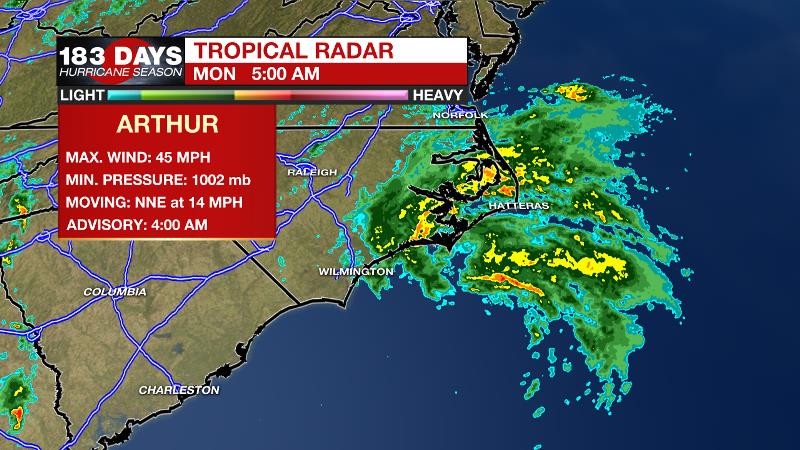
The Tropics: Tropical Storm Arthur was located over 100 miles south of Cape Hatteras, North Carolina as of 5am Monday morning. Moving northeast at 10-15mph, Arthur is expected to accelerate on Monday and turn east on Tuesday. Maximum sustained winds of 45mph could increase slightly before the system begins to lose tropical characteristics on Tuesday.
THE EXPLANATION:
An upper level low and surface connection were swirling through Mississippi and Alabama on Monday morning. Showers and clouds wrapping around the backside were pulling east of I-55 near dawn. The low pressure systems will stall over the southeastern United States through the middle of the week as they become hemmed in by Arthur in the western Atlantic. Spokes of disturbed air will pinwheel around the upper low leading to periodic upticks in rain chances. Some moisture may stray back into the local area as early as Tuesday with a spotty afternoon shower or thunderstorm. Isolated showers and thunderstorms will then stay in the forecast through the end of the week. High temperatures will depend on how much cloud cover is present and how early showers develop. Unfortunately, those are both difficult forecast challenges to resolve at the moment. The upper level low will have a chance to depart east by the weekend and the area will enter a late spring regime of warmth and humidity and pop-up showers and thunderstorms.
--Josh
The WBRZ Weather Team is here for you, on every platform. Your weather updates can be found on News 2, wbrz.com, and the WBRZ WX App. on Apple and Android devices. Follow WBRZ Weather on Facebook and Twitter for even more weather updates while you are on the go.
News
