

Latest Weather Blog
Weekend cold front to ease July humidity
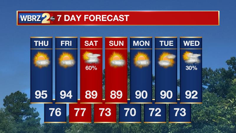
The end of the week will be dry and hot. Any pop-up showers will be very isolated. A cold front brings potential for some sensible changes by the end of the week.
THE FORECAST:
Today and Tonight: Thursday afternoon temperatures will make it into the mid 90s and thanks to mostly sunny skies. Expect a feels like temperature or a heat index to persist in the low 100s for several hours. Beneath mostly clear skies, overnight lows will again be in the mid 70s.
Up Next: Friday will be a repeat of Thursday; and then on Saturday, a cold front will come into the region. A round of strong thunderstorms will be possible as it arrives. The front will creep through the area with some lingering showers, perhaps into Sunday morning. Beyond the front, expect at least two quiet days. Temperatures will drop just 2-4 degrees below average, which isn’t really noticeable during the hot Gulf Coast summer months. On the other hand, pulling dew point temperatures down a few degrees and therefore reducing humidity, will be a change we can feel. Any relief will not last far beyond Tuesday.
The Tropics: A weak disturbance just west of the African Coast will continue to have a slim chance of organization over the next 5 days. The National Hurricane Center places a 30 percent chance of development on this cluster of showers and thunderstorms as it jogs to the west-northwest.
THE EXPLANATION:
Trending News
A mid level ridge and weak area of surface high pressure should keep convective development to a minimum through the rest of the week. High temperatures will surge well into the 90s with heat indices over 100 persisting for several hours. Moving into the weekend, a fairly significant 500mb trough will be digging out of the Great Lakes region into the Southeast. With this trough will be an accompanying cold front at the surface. Present forecast model indications are that this front will indeed make it into the local area, perhaps clearing into the Gulf of Mexico by early next week. The main impacts from this front will be felt on Saturday. With regard to showers and thunderstorms—ample heat and humidity interacting with frontal lift should be more than enough to enhance development. Cold fronts don’t often have the chance to tap our energetic summer air mass, so we will need to monitor the possibility of some strong to severe storms with gusty wind. As far as temperatures go, the upper air mass does look fairly anomalous for the time of year. Modest drying will occur and some of this will translate to the surface. At this time, forecast models are showcasing dew points down by about 3-5 degrees into the upper 60s and high and low temperatures down 3-5 degrees, near 90 and 70 respectively. This is not a major departure from average but may provide a noticeable change—especially with respect to the humidity. Return flow will kick back in on Tuesday which will return the chance of showers and thunderstorms.
--Josh
More News
