

Latest Weather Blog
Wednesday storms could produce damaging wind, a tornado
The region is at risk for severe thunderstorms fed by an unseasonably warm, humid air mass.
THE FORECAST:
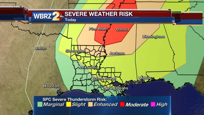
Today and Tonight: Any thunderstorms that develop on Wednesday could produce strong wind gusts or even a brief tornado. Be sure that family and friends traveling or preparing for the holiday have access to weather alerts throughout the day. The morning will begin with mostly cloudy skies and scattered showers. Temperatures will jump well into the 70s, some 10-15° above average for Late December. Thunderstorms are expected to develop and intensify during the Late Morning hours and continue through the afternoon—which is when there will be the highest chance for severe weather. The National Weather Service Storm Prediction Center has placed the local area in a “slight risk” for severe weather. For those in the risk area, this means that there is a 15% chance of a damaging thunderstorm within 25 miles of your location. Rain and storm coverage should wane into the overnight hours with just a few showers and muggy temperatures left behind. Lows will be in the upper 60s.
Trending News
Check out the video from Meteorologist Josh Eachus for a detailed video analysis.
Remember to stay connected with the weather team on Facebook and Twitter for alerts. Plus track along with live radar in the palm of your hand and get breaking alerts with the WBRZ WX. app:
Up Next: The pattern will calm somewhat on Thursday. On both Christmas Eve and Christmas Day skies will be mostly cloudy, with some breaks of sun, and a few showers. The attention-getter will be much warmer than average temperatures. Lows will be in the upper 60s with highs approaching 80°. Christmas is likely to go down as one of the warmest on record in Baton Rouge. Cooler air will not arrive until at least next week.
THE SCIENCE:
Forecast Discussion: A fast moving shortwave and associated surface low will cut through the Midwest to Great Lakes region on Wednesday. With a strong sub-tropical jet stream feeding moisture from the Pacific Ocean and a modest low level jet stream bringing additional moisture from the Gulf of Mexico—the column is primed with energy and wind shear. From a surface perspective, CAPE is forecast to jump into the 1,500-2,000 j/kg range this afternoon which is plausible given forecast high temperatures in the upper 70s. Any breaks of sunshine during the day would only add to this. Dew points will approach 70°. Helicity values are expected in the 300-400 range which denotes an atmosphere supportive of supercells. Other indices are forecast to be moderate. Limiting factors to convective development include weak lapse rates thanks to a deep marine air mass over the region. Should this mixed, saturated layer evolve too far inland, storm development could be greatly inhibited. Furthermore, a morning weather balloon sounding in the region returned a significant CAP of 4.3. It would take temperatures climbing into the low 80s to overcome this and spark off surface-based storms. There is a window of opportunity from mid-morning to mid-afternoon where instability and the strongest wind fields aloft may overlap. High resolution models suggest storm initiation around 11am in a mode of multi-cellular lines. Within these structures, there may be a damaging wind gust or brief tornado. The threats get increasingly higher from the I-12 corridor northward where the wind profiles will remain more favorable and the marine layer effects will be lower. With a loss of daytime insolation and the better wind fields exiting northeastward, the severe threat will diminish into the evening. A spring-like regime will be in place from Christmas Eve through Saturday with a stalled front in the region serving as the trigger for a few showers and storms—none of which will be severe. Skies will be partly to mostly cloud revealing a few breaks of sun at times, especially on Christmas Day and over the weekend. Temperatures will stay warm and sticky with lows in the upper 60s and highs near 80°. Most locations are expected to stay just below records. A cold front will come into the region on Monday with another threat for strong storms but also a big dip (finally) in temperatures behind it.
--Josh
Stay connected with me… share your thoughts!
Twitter: @Josh_Eachus
Google+: Josh Eachus
Facebook: Meteorologist Josh Eachus
More News
